Please click here to view full 2026 ROFFS™ North Season Fishing Forecast as a PDF.
Northeast U.S. Spring Preview 2026: RAMPING UP ALREADY
By: Matthew A. Upton
ROFFS® wraps up its 2026 spring preview series by providing an overall update of the oceanographic conditions from mid-to-late-May offshore of the northeastern United States focusing on the Mid-Atlantic Bight region and its canyons that includes the zone from Cape Hatteras to Georges Bank. We utilize a combination of many different data sets mainly satellite derived sea surface temperature (SST) and ocean color/chlorophyll images. In this report we will discuss the present ocean conditions and what it means for the upcoming late-spring to summer fishing season for the area north of Cape Hatteras, NC to Massachusetts concentrating on the offshore canyon regions.
As a reminder, for forecasting short-term oceanographic conditions related to finding fish, ROFFS® uses real-time direct observations. We have learned that evaluating the preseason conditions along with regional climate models provides insight into future seasonal trends for fishing. Experience and understanding the ocean – atmospheric dynamics is our guide as we have had moderate success in forecasting seasonal trends of fishing productivity based on the stepwise progression in the location of the fishes’ preferred habitat based on temperature and water color. Please reference our 2026 Bahamas forecast for more in-depth discussion on the environmental and climate indicators that goes into our detailed evaluation of the eastern United States fishing forecasting analysis (Click Here).
Background and Some Observations for 2026
It is important to look at the year-to-year trends including the anomalies to gain insight into the location and condition of the fishes’ preferred habitat compared with previous years. Comparing similar locations and features to last year during the same time period in mid-May we found that the SST of the core of the Gulf Stream off of Cape Hatteras, NC for 2025 was approximately 81.0°F and for this year (2026) it is about 1.5-1.8°F cooler at 79.2°F-79.5°F and about the same or slightly cooler than in 2024 (79.8°F). The SST of the coastal water off of New Jersey, Delaware and Maryland is approximately 2.0°F degrees cooler this year than during the same time period in 2025. The SST offshore (south) of Long Island to Rhode Island is also about 2.0°F to 3.0°F cooler than last year. The SST in the majority of the Gulf of Maine is 2-3°F cooler this year than last year except the coastal waters off of Massachusetts. These and other indicators that will be described below could suggest a slightly later arrival for the main population of tuna, wahoo, and mahi into the northeast U.S. region comparted to last couple of years specifically the inshore and northern canyon regions. Bluefin tuna may be in higher abundance slightly later than last year and closer to normal this year based on the cooler overall Gulf of Maine spring temperatures. The cooler overall SST in this region could be attributed to the colder winter we had and cooler spring season as it only recently (within the past week) has had relatively warmer temperatures. With that said, the waters should start to warm more rapidly the next couple of weeks with the start of June approaching usually triggering higher numbers of tuna then dolphin, wahoo and some billfish to start migrating north closer to the canyons in the upcoming weeks into late June. Unlike last year, even though the overall SST is cooler, there are some more promising eddies and features in the south and in the east that may improve fishing conditions quicker than last year for some pelagic species.
One driver for trends and weather and for the spring SST’s in the Mid-Atlantic Northeast U.S. region can be attributed to the North Atlantic Oscillation (NAO) and its negative phase during the month of January but then switching to a positive stage in February, then a much higher positive stage for March and April. NAO index is based on the atmospheric surface sea level pressure difference between the Subtropical (Azores) High and the Subpolar Low within the North Atlantic Ocean (https://www.ncdc.noaa.gov/teleconnections/nao/). Typically, positive NAO phases means higher winds, cooler SST and atmospheric temperatures (like this spring), and currently there is a strong positive phase in March and April which could mean higher winds on average and cooler SSTs going into the summer months, which may not be great for rougher fishing conditions and later arrival of the higher populations of game fish. Another factor to consider is the El Niño phase in the Pacific Ocean. Currently we are in an ENSO-neutral stage but it is forecasted by NOAA to quickly change into an El Niño stage by June and stay and transition to a strong El Niño later this year which usually means warmer SST’s in the Gulf of America (Mexico), Caribbean and east to northeast Pacific, but it remains to be seen what that means for waters offshore of the Northeastern U.S. and its fishing conditions. Last year was a La Niña year for the most part so this fishing season could be different based on the strong climatological trends.
Also, please see ROFFS® recent Southeast U.S. Gulf Stream fishing conditions analysis (Click here). These Gulf Stream conditions to the south are usually a good indicator and associated with the main populations of mahi, yellowfin tuna and marlin along with other highly migratory species migrating north during the spring months. Reports from mid-April to mid-May have already indicated decent amount of mahi, sailfish, blue marlin and tuna being caught off of Florida to the Eastern Side of the Stream and off of the Carolina’s. The wahoo action have not been as good as last year (yet). The billfish action in the Bahamas appear to be normal to above average and good like last year, which is a good sign. Based on historical observations we anticipate that these fish along with the larger populations of yellowfin tuna, mahi, wahoo and then billfish will continue to move to the northeast U.S. regions from the Gulf Stream areas and then closer to the inshore canyon regions by way of eddy features from the Gulf Stream and warming of the waters due to higher atmospheric temperatures as we get into mid-to-late June.
Nowcast Analysis
One of the most valuable features that we look at when trying to forecast the region in the Mid-Atlantic Northeast U.S. is the number, size and location of clockwise rotating warm core Gulf Stream rings or eddies that are located north of the Gulf Stream region from south of Georges Bank to offshore of New York, New Jersey to Delaware and Maryland areas. These are eddies that have broken off from the Gulf Stream and tend to slowly drift westward toward the Atlantis Canyons to Hudson Canyon and then in a southwestward direction toward the Norfolk Canyon before being pulled back into the Gulf Stream. The environment associated with warmer usually blue water (below the surface) and the strong boundaries of the eddy feature outer edges provide valuable habitat for the highly migratory large pelagic fish that enter this region in the spring and early summer seasons. This year, it appears to be more dynamic and promising with THREE clockwise-rotating Gulf Stream Warm Core eddies in the eastern northern canyon region and a large amount of direct Gulf Stream warmer and bluer water pushed way into the southern Canyons south of Baltimore Canyon due to a couple of large slow moving counter-clockwise Gulf Stream eddies that pushed up off of Maryland and Virginia.
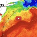
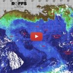
The recent spring satellite data shown in Figure 1 and 2, and the fishing reports we have already received may provide insight into the upcoming fishing season. Figure 1 was derived from a variety of U.S. (NOAA and NASA) and European (ESA) satellites to show the SST during the May 18-20, 2026 period. Figure 2 was derived from the NASA MODIS ocean color satellites (Aqua), PACE satellite from NOAA/NASA and ESA’s Sentinel 3A and 3B satellites along with SNPP and NOAA 20 & 21 VIIRS satellites showing the ocean color/chlorophyll image data during this same period of May 17-20, 2026. Please notice that this is the exact same time we did these images and observations last year.
We used a combination of imagery over about a three-day period with the time-tested ROFFS® cloud reduction algorithm to produce these relatively cloud-free images over this entire area. The time of the satellite passes and the amount of data taken from each image is not exactly the same for the SST and ocean color images. Thus, there may be some subtle differences in locations of where the water mass boundaries derived from the SST and chlorophyll/ocean color occurs. In spite of these small discrepancies this image pair is considered more than adequate for the purposes of our seasonal discussion as they were taken from the same two days.
The directional flow of the water was derived from our ROFF® sequential image analysis techniques, following the water masses, image to image based on the water mass’s distinct, i.e. signature value. An example of this year’s SST satellite infrared imagery in a greytone movie can be found on the ROFFS® YouTube™ site (https://www.youtube.com/watch?v=7o9L5tRBsw4). Viewing the movie several times allows one to visualize the flow of the Gulf Stream and other currents, where the darker greytoned water is the warmer water and white areas are clouds. Notice the progression of these larger warm-core Gulf Stream eddies and features from east to west then southwest between the Gulf Stream and canyon regions and also notice how the SST is warming over the past week.
Looking at Figure 1 and 2 (below) and comparing the conditions this year to last year, we notice some obvious differences. First of all, there is more eddies and promising features this year than last year. There are THREE main clockwise rotating larger eddies that have spun off of the Gulf Stream that will likely continue to flow west then southwest carrying good fish habitat near or over the canyons from south of Massachusetts to New York, then the southwest over the canyons off of New Jersey to Virginia through the summer months. The first eddy is a cooler older eddy centered southeast of Hudson Canyon that has already started to pull up some relatively warmer (60°F+) water from the south. The second larger and warmer clockwise rotating eddy is centered south of Oceanographer Canyon just off the 1000 fathom curve and the last one is further east centered southeast of Georges Bank and southeast of Munson Canyon but is the largest and warmest eddy. These eddies could supply the canyons all summer, especially if the Gulf Stream pulls pushes north and interacts with these eddies (and does not break them up) and they pull up warmer newer water into the canyon regions and inshore.
Second of all, is the position and angle of the Gulf Stream. This year the Gulf Stream overall, except in the very eastern area, is located further north than it was last year. This is a good sign that the warmer water within the habitat range of tuna, wahoo, mahi and billfish are closer to the canyon regions and could mean an earlier or more normal start of the more productive fishing season. Lastly, one of the most promising features is the position and location of the Gulf Stream and direct related eddies right now off of North Carolina, Virginia and Maryland. Within the last week, the Gulf Stream pushed north and inshore more than it has in a long time for this time of year. There is and has been water over 70°F to 75°F as far inshore as 30-40-50 fathoms east of the Cigar, into Norfolk to Washington and Poor Mans Canyon and southern and eastern Baltimore Canyon. There has already been marlin, mahi, bluefin and yellowfin tuna caught in these waters between Poor Mans Canyon to Washington to Norfolk Canyons and south off of Virginia. These conditions may change and blend out in the next couple of weeks, but it is a good promising sign for May and should last into Memorial Day weekend and next week.
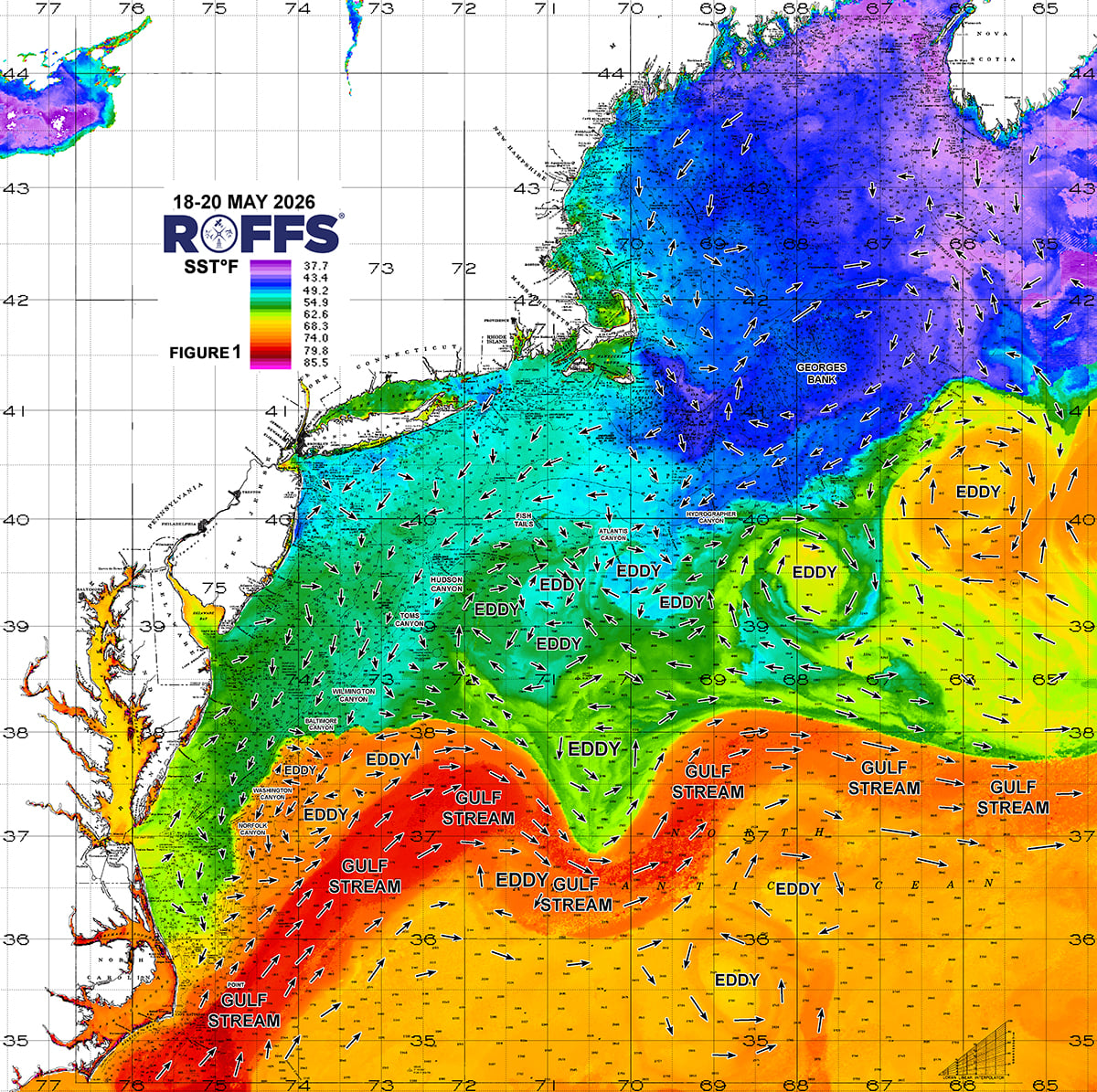
Figure 1: This year’s Mid-Atlantic Northeast U.S. conditions were derived from a variety of infrared sensors to get SST from NASA, NOAA and ESA satellites during May 18-20, 2026. Main eddy features, canyons and surface currents are labeled.
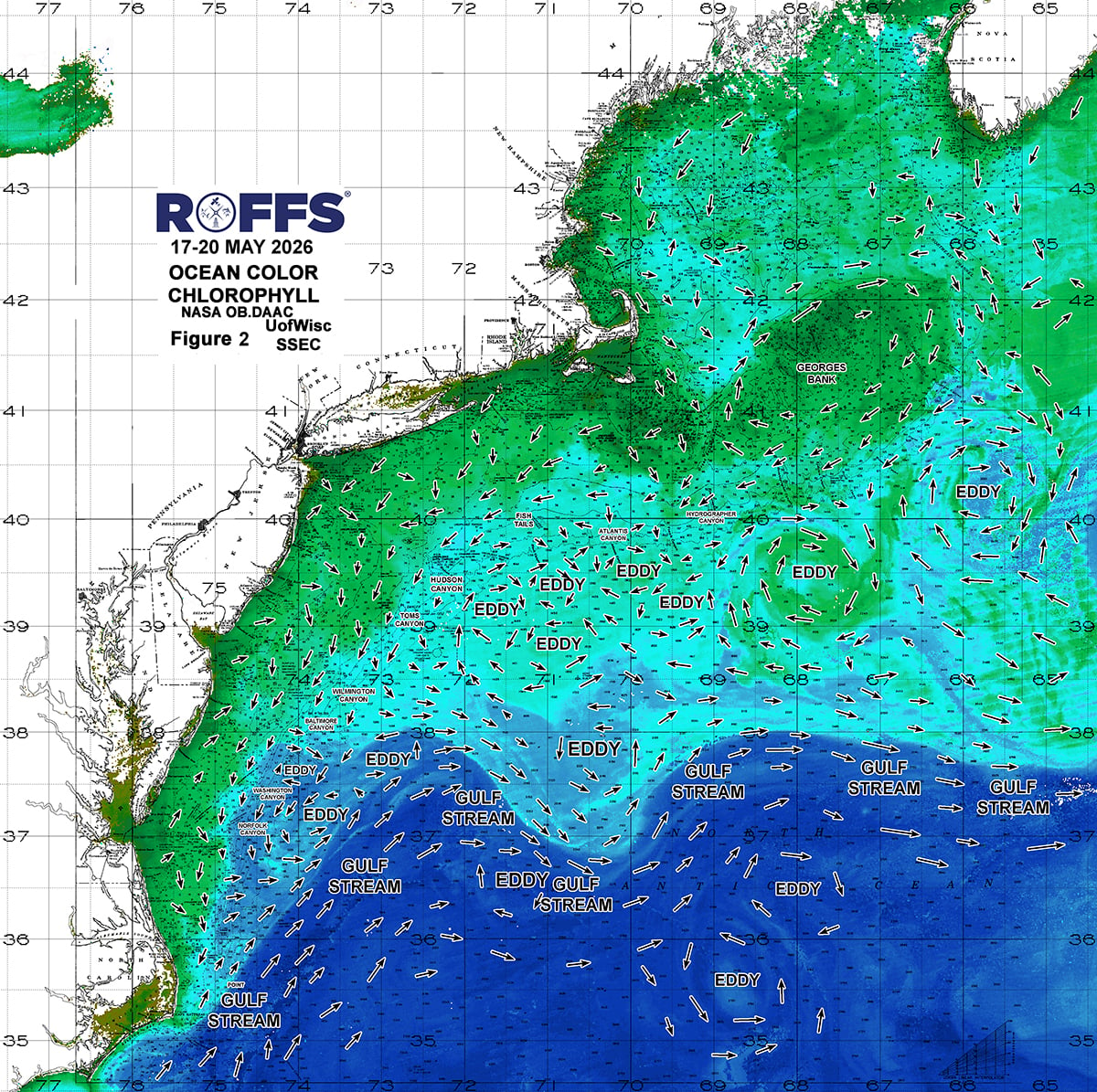
Figure 2: This year’s Mid-Atlantic Northeast U.S. conditions derived from the ocean color/chlorophyll imagery during May 17-20, 2026 from the Aqua sensors on the MODIS satellite and SNPP and NOAA 20 & 21 VIIRS provided by the University of Wisconsin, from Sentinel 3A & 3B ESA satellite data and now PACE from NASA/NOAA. We consider this an image pair with the above SST Figure 1 image. Same main eddy features and surface currents labeled.
Looking at Figure 2, notice that there is a lack of blue or even blue-green water over this entire inshore and canyon areas (except Poor Mans to Norfolk) until you get to the Gulf Stream water or way out east. Keep in mind that we are near or just after the peak season of the spring algae bloom, hence the abundance of greener water. This is an annual spring event that provides the food and the beginning of the life cycle for many of the plankton and baitfish species for the next month or two. Also, just because the surface water is greener in color offshore a few feet below the surface the water is likely clearer and bluer, especially offshore within the eddies. Not much can be derived from the ocean color trend yet as every year is different mainly based on weather and wind. The ocean color/chlorophyll signature becomes more important during the mid-to-late summer to distinguish the main water mass boundaries and features when the SST is warm and uniform.
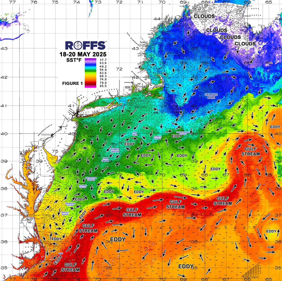
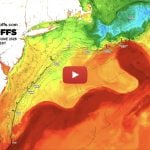
Figure 3. Last year’s Northeast U.S. conditions were derived from a variety of infrared sensors to get SST from NASA, NOAA and ESA satellites during May 18-20, 2025. Main eddy features, canyons and surface currents are labeled.
Other evidence for forecasting the 2026 main fishing season is the recent fishing reports in this region and down south. Again, except for the North Carolina and maybe Virginia crowd, it has been a slow start and we know many north of North Carolina or Virginia have not fished much yet offshore and are just getting into the tuna season. It has also been an overall cool spring and breezy many days. However, in the south off of Maryland to North Carolina, the emergence of the Gulf Stream waters further north and inshore over the past week has kicked off some decent, mahi, yellowin tuna and even marlin action early this year, not high numbers, but there are fish in that water between Poor Mans to Norfolk Canyon and south. From the reports we have heard also, blue marlin and sailfish being caught off of North Carolina and Hatteras already is a good sign. There has also been a bigger class of bluefin tuna caught recently inshore in norther New Jersey and western Long Island. There has not been a lot of tuna earlier this year off of Oregon Inlet and Hatteras, but numbers should hopefully start to improve. Further south, blue marlin and sailfish and mahi are starting to be caught in higher numbers off of South Carolina, this population should start to move north as weather and conditions warm up.
Conclusion
Based on what we have been observing over the last few of weeks, it appears that the arrival of the larger populations of billfish, tuna, wahoo, and mahi for most of the canyon regions may be normal to later than last year, except where the Gulf Stream waters pushed over the southern Canyons already. This is mainly because of the cooler winter and an overall cool spring and cooler SSTs. It is a slower than normal start to the season in the northern to mid-canyon regions. HOWEVER, the GOOD NEWS is that we are encouraged by the higher number of Gulf Stream Warm core eddies this year which is more than the previous two years. These eddies contain larger populations of game fish (especially the ones further east) and could interact with warmer Gulf Stream related water to the south and act as an early-in-the-year bridge for tuna, wahoo, dolphin and billfish to migrate inshore and into the canyon regions for better early summer/late spring fishing conditions. These eddies will start to improve the conditions for some of the north to northeast canyons now and into June and with the large eddy way out east, could mean GOOD conditions all summer for much of these canyon areas into August as these eddies progress west. What is also very encouraging is the Gulf Stream waters that pushed up and inshore already around Norfolk to Poor Mans Canyon. Hopefully this does not disrupt the normal migration, but it could keep some resident tuna, mahi and marlin in this area into June, which is much earlier than normal. BUT the overall cooler SSTs throughout this region normals out and suggest a normal to later start to the main fishing conditions. Overall the bluefin tuna population seems to be healthy and early signs of other pelagics off of Maryland to North Carolina are being reported. Once again it is shaping up to be a GOOD fishing season in the Massachusetts to Long Island canyon region and hopefully trickles down to the Hudson to Norfolk Canyon region.
We recommend that you to take a look at these early season conditions and if you have not done so already, get your boat ready and get offshore when the weather permits, as there are some bluefin tuna to be caught in the inshore waters and also some tuna, mahi and marlin already in the southern canyons. Further east, the first promising clockwise rotating eddy is not too far off of Oceanographer to Hydrographer Canyon with 62°F to 65°F tuna water in it. What is also encouraging is how the SST will be increasing next week and early June, especially inshore so it will not be long until most of the offshore regions will be within range of favorable temperatures and habitat for mahi and tuna action and soon after marlin. These conditions are already favorable now inshore off of Virginia to Oregon Inlet areas.
It is important to remember that good fishing action on a daily basis is strongly linked to local, short-term (days) current conditions that concentrate the fish once the preferred habitats of the fish are in a particular region. When the water mass boundaries associated with these currents are geographically stable and favorable, i.e., persistently pushing over “good” bottom topography and/or in a favorable inshore direction creating upwelling, then they concentrate the baitfish and larger fish can be found foraging. This indicates that the fishing action on any given day is controlled by relatively short-term (daily) and relatively small-scale (5-10 mile) movements of the currents and their water mass boundaries. Our experience indicates that to reliably forecast specific concentrations of fish on a daily basis one must evaluate the ocean conditions on these scales. Relatively small subtle changes in the currents and their associated water mass boundary zones often have dramatic effects on the distribution and concentration of fish.
Contact ROFFS® (1-321-723-5759 / [email protected] / www.roffs.com, @roffsfishing on Facebook and Instagram) for the up-to-date detailed fishing conditions and get the inside track to where the better fishing locations will be tomorrow and what is new at ROFFS®. Our experienced satellite fisheries oceanographers and front office staff will continue to monitor the Mid-Atlantic Northeast U.S. oceanographic conditions as the season quickly improves and the active summer fun fishing and tournament season rapidly approaches. Thank you for your support and as always we encourage feedback and pictures and reports.
Lastly, check out our new product FishCast powered by ROFFS® an automatic modeled forecast of the better fishing conditions overlaid directly on your Simrad® chart plotter with no additional hardware or on a desktop viewer. This is a great supplement to our regular analyses to maximize your experience out on the water. Check out this website for more information. https://www.simrad-yachting.com/fishcast/
Safe and Successful Fishing Season from Team ROFFS®