
Know WHERE to fish and WHEN.
Take the guesswork out of fishing. Select your region and inlet to unlock advanced oceanographic forecasts, seamlessly integrated as a simple C-MAP® chart overlay on select Simrad® displays.
The data backed forecast to catch MORE fish.
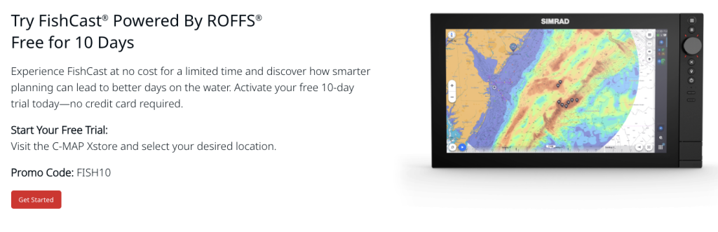
See the top fishing hot spots based on oceanographic data like water temperature (SST), ocean color/chlorophyll & optimal catch location.
Get precise forecasts in 3-hour intervals – up to 3 days in advance. All in one subscription with no new hardware.
FishCast® powered by ROFFS® available exclusively on Simrad®. It’s the fishing forecast that puts fish on your line.

Take the guesswork out of fishing. Select your region and inlet to unlock advanced oceanographic forecasts, seamlessly integrated as a simple C-MAP® chart overlay on select Simrad® displays. Smarter fishing begins with better data. FishCast®, developed by Fathom Science®, integrates world-class oceanographic forecasts combined with AI-enabled ocean analytics and over a decade of trusted ROFFS®fishing analyses, guiding you to the most promising fishing zones right on your C-MAP®charts through your Simrad® display.
Each subscription is centered on your chosen inlet, giving you tailored, location-specific intelligence where you launch and fish most.
Key Benefits
- Location-Specific Coverage Your subscription covers a 120 mile radius around your selected inlet, delivering precise data for your local fishing grounds.
- Science-Driven Analysis Fathom Science’s AI-enabled ocean analytics combine daily oceanographic data important to fish habitat such as currents, sea surface temperature, ocean color, bottom depth, and fronts with over a decade of trusted ROFFS® fishing analyses to locate the most productive waters for fishing action.
- Pinpoint Optimal Fishing Zones Hotspots are clearly highlighted on your chart, helping you target the most productive areas for your next great catch.
- Flexible Subscription Durations Choose from weekly, monthly, seasonal or yearly plans to fit your fishing schedule.
How it works
Select Your Inlet each product covers a circular area centered on the inlet you choose.
Pick Your subscription Length Choose from flexible durations to fit how and when you fish.
Access the data in Your Plotter FishCast® overlays appear directly on your C-MAP® charts, including:
-
-
- Optimal Catch Locations
- Ranked Fishing Hotspots
- Sea Surface Temperature
- Ocean Color
-
Fish Smarter Use professional-grade intelligence to navigate with confidence and head straight for the best hotspots.


