Updated Videos on ROFFS™.com – Be Sure to Check Out the “Hot News” Button on the ROFFS™ Homepage
Fish Tube!

Fish tube. Video Courtesy: Ocean Reality | Facebook
Please click HERE to watch the video on our website now!
Dock Crasher!

Terrifying video – Hornblower boat crashes into the dock. Video Courtesy: Humans At Sea | Facebook
Please click HERE to watch the video on our website now!
This Week: Visit ROFFS™ at the 2016 Gulfcoast Boat & Yacht Show – ROFFS™ Daily Seminars!
ROFFS™ will be exhibiting this year at the 2016 Gulfcoast Boat & Yacht Show! ROFFS™ will be participating, and presenting daily seminars at 2:00 pm in the ROFFS™ Seminar Tent (map below) on the topic Effects of the Ocean Environment (including eddies) on the Catchability of Tuna, Marlin, Sharks and Mahi at the 2016 Gulfcoast Yacht and Boat Show in Gulfport, MS both this weekend and next weekend Friday, Saturday & Sunday! The show will be held in Gulfport, MS both this weekend April 8th, 9th and 10th (Friday through Sunday) and again next weekend on April 15th, 16th and 17th (Friday through Sunday). At our seminars we will also be discussing background information on how and why fish search for their preferred waters.

Please click HERE to read more on this and to view the map on our website now!
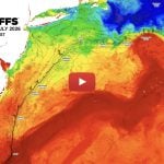
Gulf of Mexico: Blue Water (73°F-75°F) Pushing Towards the Steps and De Soto Canyon
We are providing a complimentary update of the overall ocean conditions in the Gulf of Mexico. We have included some spot sea surface temperatures (°F) and indicated the main eddy features and the main body of the Loop Current with text and arrows indicating the flow direction of the water. Overall, we continue to follow the relatively warmer water (73.4°F-75.3°F) pushing towards the Steps region and over the southern De Soto Canyon with some of this water moving northeastward towards the Spur region. We have included an ocean color/chlorophyll image along with the SST image in order for you to see the water colors in this area. The eastern edge of the main body of the Loop Current (81.3°F-81.7°F) continues to push eastward towards the western coast of Florida and occurs approximately 100 miles offshore. Westward, several large eddy features continue to pull blue (73.4°F-74.3°F-74.7°F) water towards and over the Flower Gardens Banks. Southeast of the Texas coastline we observed relatively warmer (73.2°F-72.7°F) blue water offshore. All of the previously mentioned conditions suggest a great early season of fishing with Yellowfin tuna, wahoo, dolphin, sailfish, swordfish and marlin. Please call the office now at 800.677.7633 to order a more detailed analysis of these conditions.

Please click here to view the full high resolution analysis on our website now!
Tarpon Feeding!

Tarpon feeding in Key West! Video Courtesy: FishMonster | Facebook
Please click HERE to watch the video on our website now!
Amazing Octopus!

The Amazing Ability Of The Octopus! Video Courtesy: Badass Vines | Facebook
Please click HERE to watch the video on our website now!
Another Use for a Castnet!

Fishing for criminals with a castnet! Video Courtesy: How To Fishing | Facebook
Please click HERE to watch the video on our website now!

Please click HERE to watch the video on our website now!
Happy Dog!

Please click HERE to watch the video on our website now!
Updated Client Photos/Videos

Please click HERE to our newly updated 2016 client photo gallery on our website now!
Auspicious – Winner Casa De Campo 2016

Please click HERE to watch the video on our website now!
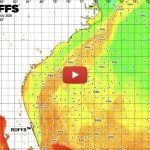
Wilmington Canyon to Norfolk Canyon Offshore Spring Special
Blue Gulf Stream water (72°F-70°F) hits the Washington Canyon and Norfolk Canyons. Tuna, swordfish and mako sharks are there.
We are providing a complimentary analysis of the overall ocean conditions within our Wilmington to Norfolk Offshore Canyon charted area. We have included some spot sea surface temperatures (°F) and located the main eddy features with arrows indicating the flow direction of the water. Overall, what we are most encouraged about is the recent push of the direct Gulf Stream and related filament water into this southern and eastern charted area and directly into the southern canyons. As you can see, there is now direct Gulf Stream filament water (68°F-70°-72°F) pushing directly over the Washington to Norfolk Canyons over the 100-500 fathom ledges but also as far inshore as 40-50 fathoms. The movement of the offshore direct Gulf Stream and related eddies has created a clockwise rotating flow east-northeast of Washington Canyon and is pushing the direct Gulf Stream filament water (68°F-70°F) farther northward into the Rockpiles and almost into Poor Mans Canyon. Therefore, get your boats ready for when the weather breaks, do not miss out on some early season tuna, mahi, wahoo, shark, swordfish and even billfish action. Contact ROFFS™ and get the up-to-date integrated fishing forecasting analysis to locate the most detailed information for the best fishing action near you.

Please click here to view the full high resolution analysis on our website now!Letter to the Editor: Devastation to Our Waters – Understanding the Real Problem
A few of my friends from the Northeast coast and abroad were planning to visit Florida to enjoy the fishing, everglades, beach and rivers, food and the lifestyle. Sadly, when I told them not to visit (because of our current devastation to our waters) they were perplexed, and not aware of what is truly going on. A few even thought that I was trying to be selfish and trying to protect my fishing spots. Believe me, I enjoy sharing and there is nothing better than to see friends catch big fish and enjoying the environment and clean waters.
I am angry. I mean extremely ANGRY! Ironically, with this anger I have to congratulate the local media, reporters, the politicians and the officials for trying to cover things up. Then again, I suppose the truth must be told… for those who aren’t aware, there are an incredible amount of self serving politicians (seriously corrupted) that has abused their power for too long and too far. They allowed greed to betray over their oath and vows of duties and promises to do their best for the state’s economy, and to preserve and protect the ecosystem and environment. More importantly, they forgot they were elected by the people, and for people. Sadly, they have been compromised by big business endorsements (legal bribery as I like to call it) and to allow practices that to pollutes and destroys what this great state represents (tourism, great ecosystem, pristine everglades, fishing capital of the world and it’s once clean oceans and beaches).

NOTICE: AL – DAUPHIN ISLAND – Naval Testing
Commencing approximately March 28, 2016 and continuing until approximately April 16, 2016, the Naval Research Laboratory will deploy research equipment at 6 mooring locations. The planned locations of the moorings are in approximate positions:
Mooring (1), 30-10-28.16N 088-01-07.57W
Mooring (2), 30-10-57.00N 088-04-40.51W
Mooring (3), 30-12-03.49N 088-07-22.15W
Mooring (4), 30-07-46.13N 088-07-23.09W
Mooring (5), 30-03-06.80N 088-07-18.91W
Mooring (6), 29-58-40.01N 088-07-16.00W
Mooring (1) will extend 2 feet off bottom. Moorings (2) and (3) will extend with a line to just below the ocean surface. Moorings (4), (5), and (6)
will extend with a line to 30-foot below surface. Nine inch in diameter white buoys with a flashing yellow 2.2s, light characteristic will be deployed to mark these subsurface moorings. Mariners are asked to not disturb these experiments and are urged to use caution when transiting the area.
Backlash? Feedback?

As always, please send comments & feedback on Fishy Times newsletter content directly to us at [email protected].
If you do not want to wait for our next Fishy Times newsletter, please visit us in the meantime to get all your fishing news on Facebook, Instagram, Twitter, YouTube and on the web. Safe and successful fishing until next time!