

Oceanographic Based Fishing Forecast for Northeast Florida to Northeast Canyons
Introduction:
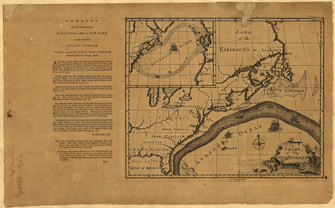
As a result of our studying the ocean conditions over the North Atlantic Ocean for more than 30 years which includes receiving observations and feedback from recreational and commercial fishermen, as well as, other scientists there appears to be several indicators that provide some insight on the upcoming ocean conditions as they relate to the presence of yellowfin tuna, blue marlin, white marlin, swordfish and dolphinfish (mahi mahi) from northeast Florida to Georges Canyon which is located on the eastern side of Georges Bank in U.S. waters by the Canadian boundary. A substantial part of this pertains to the disposition of the Gulf Stream and the sources of water that feed it from the Bahamas to the Caribbean Sea as these water masses contain the highly migratory species that move around the western North Atlantic Ocean. Fishermen such as the Spanish (Basque’) cod fishermen understood the importance of the Gulf Stream long before Benjamin Franklin realized the importance prior his publishing the now famous “Chart of the Gulf Stream” in 1769 which allowed commercial ship traffic to become more efficient.
As a graduate student I once wondered what would happen to the catch rates of tuna and billfishes off the US east coast from Virginia to Massachusetts if “there wasn’t any Gulf Stream water over the canyon and inshore waters.” One year I learned what happens and for the sake of thousands of fishermen and associated industries I hope it never happens again. Basically, no Gulf Stream water means no offshore tuna, billfish and mahi. Over the years we have learned that even when there is Gulf Stream water in our fishing zone that there are other factors controlling the relative apparent abundance of the fish that we search for.
Since 2003 I have been providing an annual seasonal fishing forecast for the Bahamas Billfish Championship (BBC) tournament season (April – June) and have observed that the apparent abundance of blue marlin in the northern Bahamas region is related to the volume of “blue marlin water” extending from the Cat Island – San Salvador island area to Eleuthera and the Abacos. See our most recent article on this at the ROFFS™ website (https://roffs.com/2014/03/2014-bbc-seasonal-forecast/). When discussing this work with many fishermen at seminars and boat shows it became apparent that the downstream disposition of this water also affected the relative apparent abundance of at least yellowfin tuna, blue marlin, white marlin and mahi in the coastal waters from Jacksonville to North Carolina. It seems that when and if this “blue marlin water” moves to the eastern side of the Gulf Stream from the Blake Plateau area (north of Little Bahama Bank) east of Ft. Pierce to Cape Canaveral, then the fish in the water mass travel with it and enter the Gulf Stream Current. The best years for fishing action with these species appear to occur when there is a near constant supply of this water and fish mixing into the Gulf Stream off east central to northeast Florida. We think of this as the giant hose that focuses the path of the fish westward to Florida. Once an abundance of fish are in the Gulf Stream system, then they are most often found along the western boundary of the Gulf Stream where the water mass boundary conditions are favorable for concentrating baitfish for these fish have to feed on during their northward migration. It then follows that as these migratory fish continue their northward and northeastward swim in the Gulf Stream, they will be found in the Gulf Stream water downstream from Florida to Europe. However, when this “blue marlin water” moves northward or northeastward, away from the Gulf Stream in the south Atlantic states coastal region, then the relative apparent abundance of these fish are greatly reduced. We do not mean reduced to zero as many fish still move northward from south Florida, Caribbean Sea and Bahamas Bank between Cuba and Andros Island into the Gulf Stream Current.
You have got to see the full size satellite images of the ocean conditions now!
Please click HERE to read the full article and see the full size figures on our website…

If you do not want to wait for our next Fishy Times newsletter, please visit us in the meantime to get all your fishing news on Facebook, Twitter, YouTube and on the web. Safe and successful fishing until next time!


