Introduction:
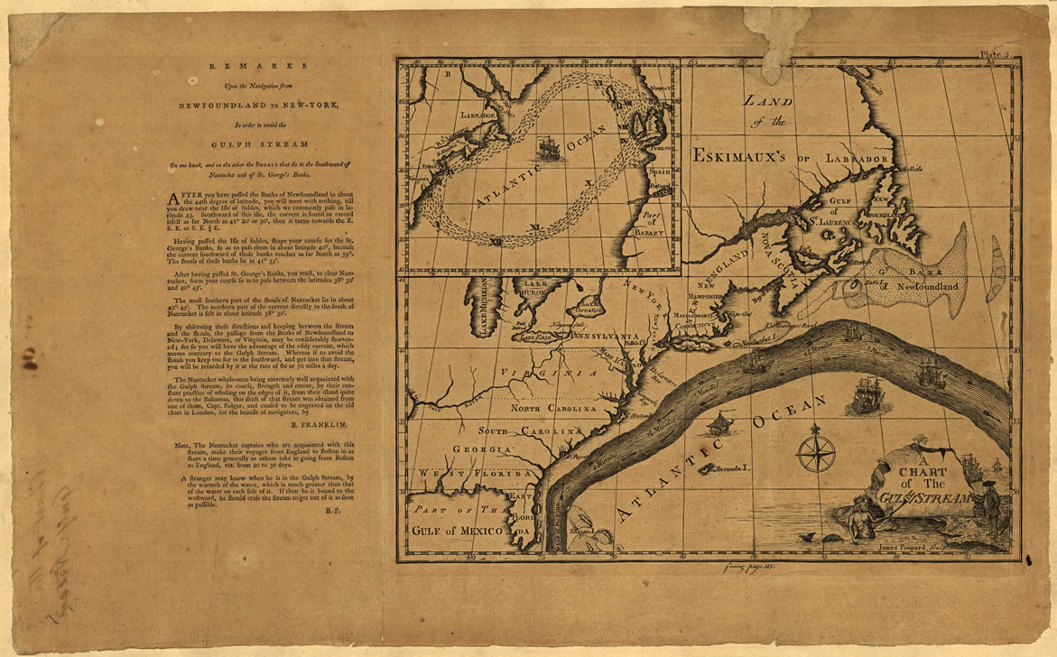
As a result of our studying the ocean conditions over the North Atlantic Ocean for more than 30 years which includes receiving observations and feedback from recreational and commercial fishermen, as well as, other scientists there appears to be several indicators that provide some insight on the upcoming ocean conditions as they relate to the presence of yellowfin tuna, blue marlin, white marlin, swordfish and dolphinfish (mahi mahi) from northeast Florida to Georges Canyon which is located on the eastern side of Georges Bank in U.S. waters by the Canadian boundary. A substantial part of this pertains to the disposition of the Gulf Stream and the sources of water that feed it from the Bahamas to the Caribbean Sea as these water masses contain the highly migratory species that move around the western North Atlantic Ocean. Fishermen such as the Spanish (Basque’) cod fishermen understood the importance of the Gulf Stream long before Benjamin Franklin realized the importance prior his publishing the now famous “Chart of the Gulf Stream” in 1769 which allowed commercial ship traffic to become more efficient.
As a graduate student I once wondered what would happen to the catch rates of tuna and billfishes off the US east coast from Virginia to Massachusetts if “there wasn’t any Gulf Stream water over the canyon and inshore waters.” One year I learned what happens and for the sake of thousands of fishermen and associated industries I hope it never happens again. Basically, no Gulf Stream water means no offshore tuna, billfish and mahi. Over the years we have learned that even when there is Gulf Stream water in our fishing zone that there are other factors controlling the relative apparent abundance of the fish that we search for.
Since 2003 I have been providing an annual seasonal fishing forecast for the Bahamas Billfish Championship (BBC) tournament season (April – June) and have observed that the apparent abundance of blue marlin in the northern Bahamas region is related to the volume of “blue marlin water” extending from the Cat Island – San Salvador island area to Eleuthera and the Abacos. See our most recent article on this at the ROFFS™ website (https://roffs.com/2014/03/2014-bbc-seasonal-forecast/). When discussing this work with many fishermen at seminars and boat shows it became apparent that the downstream disposition of this water also affected the relative apparent abundance of at least yellowfin tuna, blue marlin, white marlin and mahi in the coastal waters from Jacksonville to North Carolina. It seems that when and if this “blue marlin water” moves to the eastern side of the Gulf Stream from the Blake Plateau area (north of Little Bahama Bank) east of Ft. Pierce to Cape Canaveral, then the fish in the water mass travel with it and enter the Gulf Stream Current. The best years for fishing action with these species appear to occur when there is a near constant supply of this water and fish mixing into the Gulf Stream off east central to northeast Florida. We think of this as the giant hose that focuses the path of the fish westward to Florida. Once an abundance of fish are in the Gulf Stream system, then they are most often found along the western boundary of the Gulf Stream where the water mass boundary conditions are favorable for concentrating baitfish for these fish have to feed on during their northward migration. It then follows that as these migratory fish continue their northward and northeastward swim in the Gulf Stream, they will be found in the Gulf Stream water downstream from Florida to Europe. However, when this “blue marlin water” moves northward or northeastward, away from the Gulf Stream in the south Atlantic states coastal region, then the relative apparent abundance of these fish are greatly reduced. We do not mean reduced to zero as many fish still move northward from south Florida, Caribbean Sea and Bahamas Bank between Cuba and Andros Island into the Gulf Stream Current.
Present Conditions and Analysis
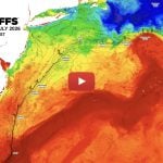
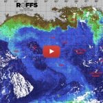
Figure 1 is a color enhanced satellite image of sea surface temperature from combining infrared satellite data from U.S. and European satellites during the relatively clear April 02 – 03, 2014 period from the eastern Gulf of Mexico to North Carolina. This illustrates the location of the “Bahamas blue marlin water”, the Gulf Stream, Loop Current and several clockwise and counter-clockwise rotating eddy features east of the Gulf Stream. We have not indicated the other eddy features along the western boundary of the Gulf Stream. Figure 2 is an ocean color image from the VIIRS sensor on the U.S. Suomi National Polar Orbiting Partnership satellite derived from the same days. Remember that there are more satellite images from the infrared (sea surface temperature) satellites compared with the ocean color ones that facilitates cloud reduction. Note the signature darker blue color of the Bahamas blue marlin water that allows one to relatively easily monitor this water type. Also note that one can not always follow the color of the water from following the sea surface temperature (sst) as some people try to do. That is a subject for another article.
These images show that the Bahamas blue marlin water east of Cat Island – San Salvador area (bottom right hand corner of Figures 1 and 2). This water has been pulled northwestward toward Eleuthera by a clockwise rotating eddy north of the marlin water (centered near 74°00’W & 26°30’N), but instead of being forced to Abaco, it is being pulled northeastward. Some of the water has reached the fishing grounds off Abaco which is favorable for marlin action there. For the best yellowfin and marlin fishing action downstream (off northeast Florida, Georgia and South Carolina) the Bahamas blue marlin water should be directed toward the eastern side of the Gulf Stream between Ft. Pierce and Cape Canaveral. Based on the information in Figures 1 and 2 one can see that only some of the Bahamas marlin water has been transported not east, but north of the Bahamas Island chain due to the flow of a counter-clockwise eddy (centered near 78°00’W & 28°30’N) east of the Gulf Stream and north of Walkers Cay. In addition, the water has been pulled northward by two other eddy features. This suggests that in the coming weeks a relatively slow flow of yellowfin tuna and marlin will occur toward northeast Florida to South Carolina. However, this is much better than we have seen in recent years where almost none of this water flowed into the eastern side of the Gulf Stream.
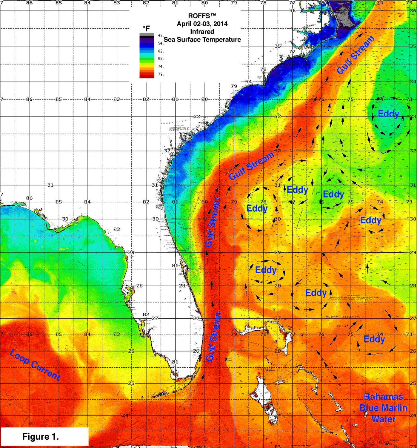

Over the longer term it is possible that the clockwise eddy now east of the Abacos will drift northwestward and start pulling the productive yellowfin tuna and marlin water toward central Florida improving the situation substantially. Presently the location and flow of the blue Bahamas water suggests that marlin and tuna are on the east side of the Gulf Stream between northeast Florida and South Carolina.
Certainly the lack of the Bahamas blue marlin water off Florida is not a good omen for bringing an abundance of fish early (now) to the Georgia to North Carolina zone. However, the Bahamas water has been pulled northward and forms a relatively large pool substantially east of Jacksonville (73°30°-76°00’W & 29°00-30°00’N) that continues to be pulled northward by a clockwise rotating eddy (centered near 74°30’W & 30°00’N). Additionally, some of this water is being pulled in a northwestward motion by a system of three eddy features east of southern Georgia. As these eddy features continue to pull water and fish northward from the Bahamas, they are likely to enter the Gulf Stream between Savannah, GA and Charleston, SC. Increasing the likelihood of marlin and tuna action north.
For the northern part of South Carolina and North Carolina it is too early to forecast, with any confidence, of what will happen. We do not know of any models that reliably forecast the motion of these eddy features in the temporal and spatial scale required to provide an accurate fishing forecast. The relatively large mass of the Bahamas blue marlin water being pulled northward by the clockwise rotating eddy near 74°30’W & 30°00’N is favorable for bringing the fish northward. Some good catches of yellowfin tuna have already been reported from Gulf Stream waters north of Cape Hatteras which suggests that this water has an abundance of yellowfin tuna already. While it remains to be seen what happens to this eddy the good news is that is likely to move northward pulling the water and fish toward North Carolina and the Gulf Stream downstream. Southeast of Cape Hatteras along the eastern side of the Gulf Stream there is yet another eddy (counter-clockwise) centered near 73°40’W & 33°00’N that is pulling a elongated filament of water that is a mixture of Gulf Stream and North Atlantic Ocean water. While we anticipate that this eddy will pull some of the Bahamas water northeastward, the eddy is likely to be pulled northward over the next several days and not exert as much pull on the Bahamas water compared with the advection of the Bahamas water by the Gulf Stream along the eastern side of the Gulf Stream between Georgetown, SC and Cape Hatteras, NC.
North of Cape Hatteras to Georges Bank
By the time the Bahamas blue marlin water enters the Gulf Stream and mixes we are not able to distinguish the Bahamas water from the Gulf Stream water by either water temperature or color. Perhaps this could be done using other frequencies of light sensed by the satellites that we are not currently using. Perhaps the next generation of satellites could be designed to accomplish this if it cannot be done now. Given that one must have an abundance of these migratory fish in the Gulf Stream when the current passes Cape Hatteras, it appears that the key to having an abundance of yellowfin tuna, marlin, swordfish, and mahi northeast of Cape Hatteras is the presence of Gulf Stream water over the continental shelf particularly over the 100 fathom (200 meter – 600 foot) depth. While we know that tuna, marlin, swordfish and mahi enter the Gulf Stream east of Cape Hatteras, we do not know what contribution of these fish make to the total number of highly migratory fish entering the Gulf Stream. More tagging studies are needed urgently to understand this aspect.
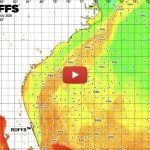
Figure 3 is an false color enhanced sea surface temperature image derived from infrared sensors on the U.S. and European satellites during April 05 – 07, 2014 from Cape Hatteras, NC to Nova Scotia, Canada. While there is substantial cloud interference south of the Gulf Stream, most of the important ocean features related to the Gulf Stream are obvious.
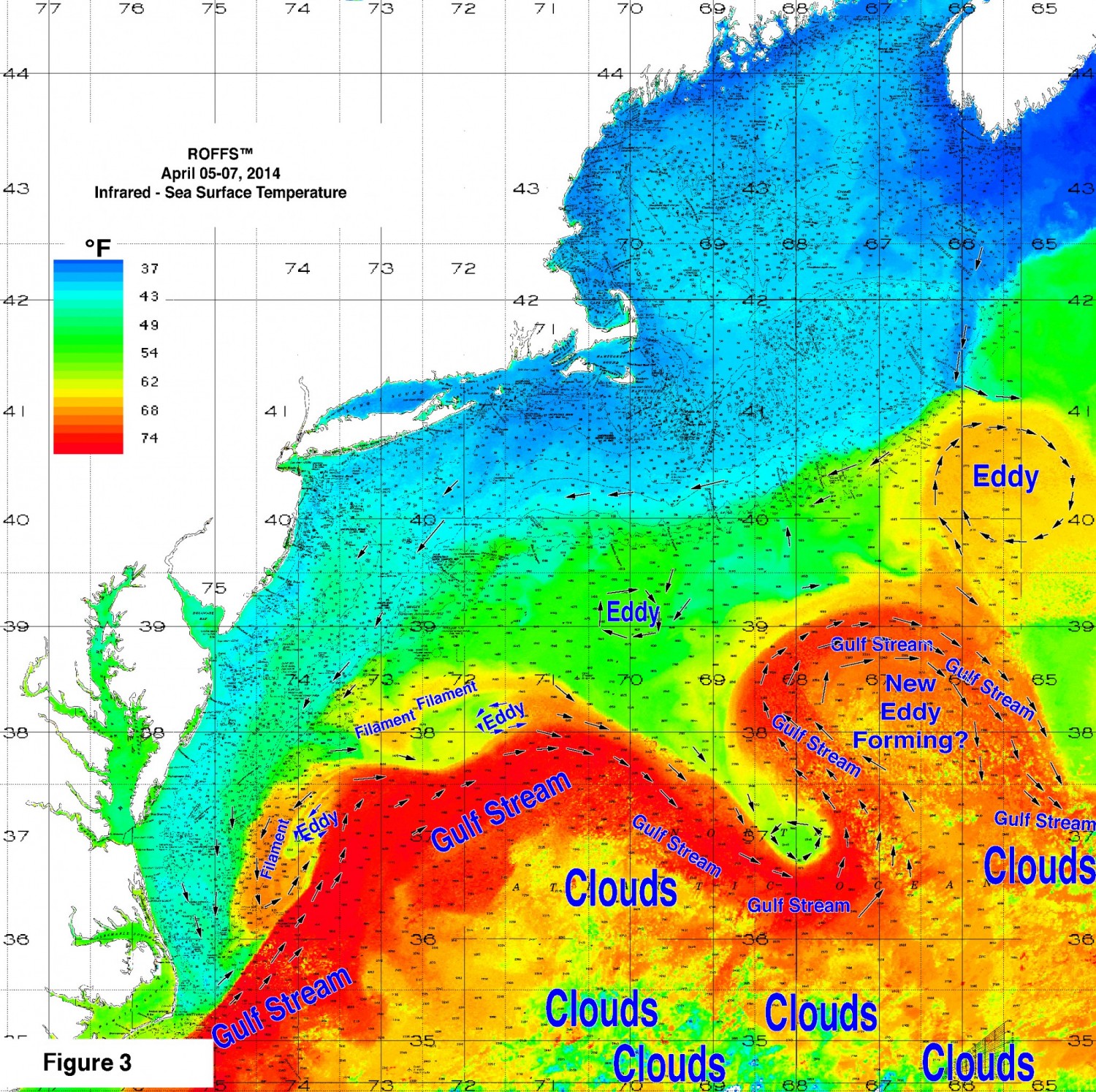
The good news now is that this week we already received reports of an abundance of yellowfin tuna northeast of Norfolk, VA along the boundary of the Gulf Stream and filament near 73°30’W & 37°30’N. This area has a relatively small counter-clockwise rotating eddy that pulled an elongated filament of water with sst of 74°F-67°F southwest to near 74°30’W & 36°00’N (northeast of Oregon Inlet, NC). These filaments are usually associated with excellent tuna, mahi, marlin, and sailfish fishing action in the late spring, summer and fall when the water is warmer and when more of the fish are moving northward. The number of such filaments can not be forecasted, but when the Gulf Stream has a more north to south orientation, like in Figure 3, then we have observed that the frequency of the filaments passing over the 100 fathom curve is increased. We also do not know any reliable way of forecasting the angle of the Gulf Stream over the weekly and monthly time scale as we would need to better forecast the summer’s fishing action. Note the other filament of Gulf Stream water north over the Wilmington Canyon area (near 73°30’W & 38°20’N) east of Delaware Bay. During the late spring, summer and fall months these types of filaments also bring tuna, billfish and mahi to the canyon areas. Currently we do not anticipate yellowfin tuna there as the surface water temperatures are in the 60°F-61°F range which is below their preferred thermal habitat. However, we would not be surprised to learn that there were bluefin tuna, blue sharks, mako sharks and swordfish in this feature. We have not included bluefin tuna or the other tunas into this article as it would too much additional text. The bluefin tuna will likely be the subject of a future article as we have been conducting research on bluefin tuna and most of the other highly migratory species the last eight years through a variety of grants from NASA and NOAA over the Gulf of Mexico, and other areas of the North Atlantic Ocean.
Large Eddy Features in the Northeast
The most significant water masses that are associated with the arrival of an abundance of highly migratory fish are the relatively large, clockwise rotating, Gulf Stream eddy features. While we observe counter-clockwise rotating eddy features in the waters off the middle Atlantic States (Mid-Atlantic Bight), the large clockwise eddy features are the ones most responsible for bringing Gulf Stream water and fish to the continental shelf. One of the significant aspects related to bringing fish is the time which the eddy forms. If the eddy forms when there is an abundance of fish in the Gulf Stream, then there will be good fishing associated with it. But if the eddy forms too early, when most of the highly migratory tuna and billfish are south, then it will not contain an abundance of fish. It is as if you have a commuter train arriving at the station empty, i.e., no one is aboard. Keep in mind that some of these eddy features can be 150 miles in diameter and extended to 1200 feet of water. So when they are filled with fish, they provide fishing action for the several months that it takes for them to drift from the Georges Bank to the Norfolk Canyon off Virginia. Also during the summer these large eddy features often get resupplied with fish, when they interact with the Gulf Stream and add “fresh” Gulf Stream water.
Presently (Figure 3) there is a relatively large clockwise eddy (mostly 67°F) southeast of Georges Bank pulling 59°F-64°F water over Georges Canyon to Munson Canyon. (Hello bluefin). This eddy is interacting with the Gulf Stream adding 69°F water now and likely to be adding 74°F water over the next week or two as the eddy interacts with the nearby Gulf Stream. As we already know that there are yellowfin tuna in the Gulf Stream off Virginia, we anticipate that this eddy is like a train at the station where people (fish) are getting aboard. Following this analogy, it is not rush hour yet as the bulk of the yellowfin tuna, marlin, swordfish and mahi populations are still south. However, these conditions are favorable for an abundance of fish to enter into the eddy over the next few weeks especially if it continues to pull new Gulf Stream water.
I am not ready to carve this part into stone, far from it
The eddy has been relatively stationary for several weeks and our experience suggests that the eddy will not be drifting westward until it becomes smaller and reduce the eastward pull on it from the eastward moving Gulf Stream Current. While there may be other relatively large eddy features forming, we believe that this is the eddy that we expect to provide the bulk of the fishing action in the middle Atlantic states this summer. We anticipate that the eddy will survive the interaction with the Gulf Stream as we recognize that we have often seen the Gulf Stream degenerate and absorb such eddy features. (Shame on us for even mentioning this, bad gazook). We have no way of estimating when this eddy will start to move westward, but if experience is any guide then we anticipate that the western boundary of the eddy will be between Lydonia Canyon and Oceanographer Canyon the first week of May, over Veatch Canyon the first week of June, over the Block Canyon over the first week in July, over the Toms Canyon area the first week in August and south after. Let me remind you that I am really going out to the edge of the limb of the branch on the tree when I write this as there are so many other aspects of the Gulf Stream circulation (new eddy features, large meanders, filaments), currents on the continental shelf, major weather events that can and likely to influence this eddy. It will be interesting (I hope) over the next weeks and months to see how good this forecast is. I included this part in the article because I am often asked what I think about will happen to it. Well now I am going public. I must be crazy.
There is another relatively small, clockwise rotating eddy south of Cape Cod centered near 70°00’W & 39°00’N. This is not of Gulf Stream origin and has sst of mostly 56°F. Based on the size, location (over 1500 fathoms) and proximity to the Gulf Stream we do not anticipate that this eddy will be a major contributor of fish this year as we anticipate that it will be pulled southward toward the Gulf Stream and be absorbed.
For the area between Carteret Canyon and Norfolk Canyon, it appears under the present conditions that the arrival of an abundance of yellowfin tuna, marlin, swordfish and mahi will be dependent on the production of Gulf Stream filaments unless new eddy features form over the next several weeks. These filaments will provide pulses of fish over the nearest canyon areas. We do not know anyone who can accurately and reliably forecast the north-south orientation of the Gulf Stream as it passes Cape Hatteras. However, we believe that during certain years that this current is oriented more in a northeast (45°) direction, yet during other years it is more east – northeast (30°), while others it can be more northward (60°). It seems that when the angle of the Gulf Stream is greater than 45° (approximately) the frequency of the formation of Gulf Stream filaments that pull water and fish to the canyons is much greater. The timing of these is a function of the formation of eddy features off Cape Hatteras and we have not found any reliable models for this either. (If we want to learn more about the ocean circulation we have to demand that our legislators to provide significantly more funding to ocean research). The good news is that over the last few weeks the Gulf Stream appears to have been oriented more near 45° and there seems to have been a greater frequency of these eddy features forming off Cape Hatteras that are pulling substantial filaments toward the continental shelf. We can only hope that this continues and happens in June, July and August to bring the fish westward. We also hope that a big eddy forms off this zone in late June.
Please pay attention to the NOAA NMFS Northeast Fisheries Science Center’s upcoming “Ecosystem Advisory for the Northeast Shelf Large Marine Ecosystems” which is likely to suggest that this spring and summer will have relatively warmer sea surface temperatures for the northeast U.S. compared with mean sst. This implies that the arrival of the inshore coastal species will not be late and may arrive earlier than years past. The ocean climate data and models suggest that spring will continue to arrive earlier and fall coming later. This translates to longer fishing seasons for most people. More on this in a future article. These folks are also doing great work on fisheries climatology.
Bottom Line
We have seen ocean conditions more favorable than the present ones which we presented and we have seen conditions worse. It is a challenging work to forecast an entire season based on several weeks of ocean circulation information even with 30+ years experience. This comes with the assumption that the rate of overfishing has not increased that would reduce the overall abundance of these fish. (Yet another article to come). It is comforting to some that we have two working crystal balls in our office that we use regularly. There is so much that we do not know and there is so much that can change between now and the fishing season. We realize that we are not going to make everyone happy with this forecast. In earnest we believe that everyone should fish as often as the weather permits. We have not discussed school, medium and giant bluefin tuna or bigeye, albacore, and skipjack tuna, wahoo, mako, dusky, thresher or other large pelagic sharks. The fishing action over the years has been excellent with these species and an abundance of some of these species has resulted in fantastic fishing in different areas. Last year (2013) will long be remembered as the Year of the Bigeye Bite north of Cape Hatteras. This year is already known as the Year of the Wahoo off northeast Florida. Remember that these fish will be moving northward to an area near you.
Important Note
Also it is critical to note that good fishing action on a daily basis is strongly linked to local ocean conditions that concentrate the bait fish and larger migratory fish once the preferred habitat of the fish are in a particular region. When the important water mass boundaries are favorable, i.e., persistently pushing over “good” bottom topography, then they concentrate the bait fish and larger fish can be found foraging on the prey. This means that the fishing action on any given day is controlled by relatively short term (hourly to daily) and relatively small scale (1-4 mile) movements of the currents and their water mass boundaries. Our experience indicates that to reliably forecast specific concentrations of fish on a daily basis one must evaluate the ocean conditions on these scales and provide daily updates. Relatively small subtle changes in the conditions often have dramatic effects on the fishing action. These daily fishing forecasting analyses provide the best chances to find the feeding fish with the least amount of time and fuel.
Get ready for the season because it is coming to an area near you soon if not there already. You do not want to be sitting at the dock or worse with your boat in storage when favorable conditions form.
We will continue monitoring these developments as the season progresses and will provide updates.
Coming soon hopefully next week: Gulf of Mexico seasonal forecast. FYI, people are already catching yellowfin tuna, swordfish, mahi, and bluefin tuna.
Remember that every fishing trip is important! A day on the water is the best therapy for everything.
Safe and Successful Fishing.