Please click here to view full 2024 ROFFS™ Bahamas Season Fishing Forecast as a PDF.
Bahamas Season Fishing Forecast for 2024: FISHING IS ALREADY HEATING UP
By; Matthew Upton
Introduction
For the past 22 years ROFFS™ has been forecasting the overall ocean and fishing conditions during the spring Bahamas Fishing Season from March through early June. The hypothesis for forecasting the seasonal marlin fishing action stems from the location of the darker blue and often warmer water that occurs from the Cat Island – San Salvador Island area and south to southeast of these islands where it is presumed that the marlin concentrate before, during and after spawning. We have been calling this water “blue marlin water” in our analyses. From satellite data, we can identify this water based on its ocean color/chlorophyll signature and sea surface temperature (SST) characteristics. Our hypothesis and experience have shown that the marlin and other pelagic species (such as tuna, dolphin and wahoo) are associated with this water and the more “blue marlin water” that exists in the Abaco Islands and Eleuthera Island areas early in the season, the greater the relative abundance of marlin in these areas.
We have also observed an association between the “blue marlin water” and the tuna and wahoo action in the Bahamas, northward along the western side of the Gulf Stream between Jacksonville, Florida and northward towards Cape Hatteras, North Carolina. We do observe evidence that when more “blue marlin water” passes north and northwest of Abaco to the eastern side of the Gulf Stream earlier in the season that a certain unknown proportion of the migratory fish move to the western side of the Gulf Stream and north. This brings more fish to the coastal fisheries at the edges of the Gulf Stream water throughout the spring to early summer season from northeast Florida to North Carolina.
Based on our observations in the Bahamas from Eleuthera to the Abacos over the last 37 years, it appears that excellent fishing action occurs within the Bahamas areas when there is a substantial volume of the “blue marlin water” pushing over the 100-500 fathom (600-3000 feet) and shallower ledges along the eastern side of Cat Island, Eleuthera and the Abacos. Relatively favorable fishing seasons occur when this water only occurs over the 500-1000 fathom depths, but does not reach the 100-500 fathom or shallower depths. Mediocre to poor years occur when there is a lack of this water over these areas or the “blue marlin water” is way offshore and pushes more north of the Abacos instead of west to northwest. However, in these cases, short pulses of this water bring fish into these areas regardless. Unless there is a sustainable flow of the water into these regions, the catch rates remain below average to average through the season. It is also important to understand that good fishing action on a daily basis is linked to the water mass boundaries created by these currents and eddies, where they are stable for consecutive days over good bottom structure and ledges and where the water is pushing in a favorable inshore direction over good structure toward the islands. These features, that have remained favorable for multiple days, concentrate the baitfish and draw bigger fish into these areas.
The hypotheses and observations are also based on our experience using hourly and daily satellite data of the ocean conditions derived by ROFFS™ (www.roffs.com), catch reports provided by a variety of sources for the past 37 years and information derived from other sources of oceanographic data. We mainly use infrared (IR) satellite data to observe the sea surface temperature (SST) and the ocean color/chlorophyll data for indices of phytoplankton (chlorophyll), water clarity, and colorized dissolved organic material (CDOM) that are received from a variety of data sources including NASA, NOAA, and the European Space Agency (ESA) satellites.
Background and Data for 2024
Although we have learned that the favorable oceanographic conditions develop from the presence or absence of the “blue marlin water” during the main Bahamas fishing season, we continue to prepare the annual forecast from data around mid-March. This allows us insight into the conditions prior to the spring season and understand the ongoing fishing success starting in March and continuing to June. We prefer to use real-time observations and have learned that evaluating the preseason conditions in February and March provides insight into future seasonal trends. We evaluate whether or not we are observing “normal” conditions or anomalies. We rely on real time satellite data, but also consult climate models. One indication is the SST in the core of the Gulf Stream off Miami and the SST of the Bahamas “blue marlin water” east of Cat Island to east of Long Island. Because we started our forecasting studies during the first week or two of March in 2003 we have continued our time series using that same time period to directly compare each year.
The ROFFS™ 22 year (2003-2024) mean SST for the core of the Gulf Stream off Miami is 78.8°F during our standard early to mid-March measurement period. This year the SST was approximately 79.3°F in the core of the Gulf Stream off of Miami on March 17-18 (2024), which is almost 1°F cooler than during the same period as the previous year (2023) and about 0.5°F cooler than 2022 but only 0.4°F warmer than the 22 year mean. While we have not been recording the SST of the Bahamas “blue marlin” water offshore of Cat Island to Long Island as long, the 17 year mean (2008 – 2024) SST for the warmer water east of Cat Island area is 76.8°F. This year the SST of the “blue marlin water” east of Cat Island/Long Island was about 76.8°F – 77.0°F during the standard early to mid-March time period and about 1.8°F cooler than last year, but very close to the mean or perhaps very slightly warmer (0.1°F – 0.2°F). Overall the observations this March indicates that the SST is cooler overall and the Bahamas “blue marlin water” is overall cooler than the previous two years and similar to the conditions in 2020 and 2021 which is considered normal conditions for this area. This suggests a more “normal” arrival of the higher numbers of billfish, tuna and wahoo action in this region and perhaps a later arrival of these higher populations of fish compared to the last two years.
Furthermore, we continue to monitor climate variability and ocean-wide circulation and consider other indices such as the North Atlantic Oscillation (NAO) and the Atlantic Multidecadal Oscillation (AMO). The NAO is the dominant mode of climate and seasonal variability in the North Atlantic region ranging from central North America to Europe and much into north Asia. The NAO is a large-scale variation in atmospheric mass between the subtropical high and the polar low. The corresponding index varies from year to year and month to month, but also exhibits a tendency to remain in one phase for intervals lasting several years. The NAO is a climatic phenomenon in the North Atlantic Ocean defined as the difference of atmospheric pressure at sea level between the Icelandic low and the Azores high. Through east-west oscillation motions of the Icelandic low and the Azores high, it controls the strength and direction of westerly winds, currents, and storm tracks across the North Atlantic Ocean. It appears to be one of the most important manifestations of climate fluctuations in the North Atlantic (https://www.ncei.noaa.gov/access/monitoring/nao/). This year (2024) the NAO index for January and February is lower in January but slightly higher in February than last year (around 0.21 and 1.1 respectively) and considered slightly higher than normal. Typically the NAO is more important for driving the west to east winds (westerly’s) from 30°N latitude and north. Higher NAO index values or an increase in NAO index suggests stronger wind and more cooling so we expect both the atmospheric temperature and SST to be cooler than last year and normal to cooler than average which has been the case down south. It was a normal or cooler than normal winter in the Florida and Bahamas area, but a milder/warmer winter in the north compared to last year.
The Atlantic Multi-decadal Oscillation (AMO) has been identified as a coherent mode of natural variability occurring in the North Atlantic Ocean with an estimated period of nearly 100+ years. It is based upon the average anomalies of sea surface temperatures (SST) in the North Atlantic basin, typically over 0°-80°N latitude. (https://climatedataguide.ucar.edu/climate-data/atlantic-multi-decadal-oscillation-amo). The AMO Index for January and February 2024 is approximately 1.07 and 1.17 respectfully which is significantly higher than last year suggesting higher SST anomalies and a positive AMO. We have learned that the current positive trend in these indices suggest a decrease in speeds of the North Atlantic Ocean Circulation is occurring. This includes a slow decrease in current speeds of the Gulf Stream system. Also, a positive AMO is usually associated with a potential increase in the number of tropical storms that mature into hurricanes because the overall North Atlantic Ocean SST is higher. This does not take into account the wind shear variability and other aspects of tropical storm genesis. For easy to understand answers to frequently asked questions about the AMO see http://www.aoml.noaa.gov/phod/amo_faq.php#faq_2.
Regarding El Niño we have yet to observe any direct relationship between El Niño – La Niña and the Southern Oscillation (ENSO) and the oceanographic conditions in the Bahamas area. Currently we are in an El Niño phase. We have been in an El Niño stage for the better part of eight months suggesting a decreased amount of tropical storms in the North Atlantic Basin, which does not line up with the current AMO readings of larger anomalies. However, the forecast for the next few months are to progress toward an ENSO neutral stage in April-June and then to another La Niña phase later this year (https://www.cpc.ncep.noaa.gov/products/analysis_monitoring/lanina/enso_evolution-status-fcsts-web.pdf).
Nowcast Analysis
In this section we want to discuss and present the current oceanographic conditions (Figure 3 and Figure 4) and compare them to last years conditions (Figure 1 and 2). For clarification purposes Figures 1 and 3 were derived from a variety of NASA, NOAA, ESA, and JPSS satellite SST sensors during the mid-March period and Figures 2 and 4 were derived from the VIIRS, Sentinel 3, and NASA MODIS Aqua/Terra ocean color/chlorophyll imagery during relatively same mid-March time period. We also try to stay relatively consistent with our color palettes through the years to make it easier to directly compare the conditions by satellite signature.
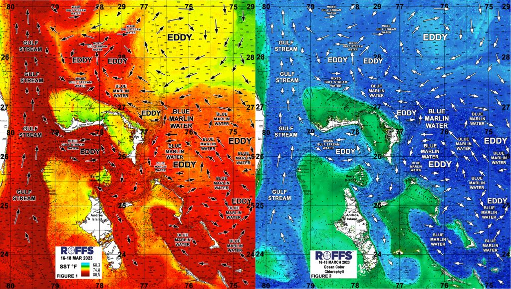
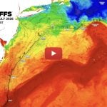
Figure 1: Last years conditions were derived from a variety of infrared sensors to get SST from NASA, NOAA, and ESA’s Sentinel 3 satellites during March 16-18, 2023 and Figure 2: Derived from the ocean color/chlorophyll imagery during March 16-18, 2023 from the ESA Sentinel 3 satellites, VIIRS sensors on SNPP satellite in combination with the Aqua and Terra sensor on the MODIS satellites provided by the University of Wisconsin SSEC. We consider this an image pair.
In both instances, we could not use single and same day imagery for the SST and ocean color data due to cloud cover interference, so we used a combination of imagery and the ROFFS™ cloud reduction techniques to produce these relatively cloud-free images. However, for comparison purposes we consider these images as an equal image pair for the purposes of this discussion. While these provide a visualization of the mid-March conditions, they also provide examples of how the eddy features, or lack of eddy features, and the water circulation are pulling the “blue marlin water” through the Bahamas. This is important for understanding the dynamics of the region. Both images for each year have the same arrows, eddy and “blue marlin water” labeling. The flow of the water was derived from our ROFFS™ sequential image analysis of Lagrangian coherent features where we study several days of satellite imagery to follow the signature water masses and their motion. An example of this years SST satellite infrared imagery can be found on the ROFFS™ YouTube site at (https://www.youtube.com/watch?v=He13FoUgY5s) showing the flow of the water around the Bahamas region during the last two months, where the darker grey water represents the warmer water and white represents clouds.
Every year is different, and this year is no exception as the waters around the Bahamas look quite different than the past few years in many ways but also similar in other ways. What is similar to last year is the lack of higher amounts of darker blue marlin water that has made its way north of Abaco and to the Gulf Stream. This lack of large abundances of “blue marlin water” already interacting with the Gulf Stream indicates that there is likely less of the main marlin, mahi and tuna population in middle to northern Bahamas region and perhaps a later than normal arrival of the majority of these species in the northern Bahamas and further north along the coast of Florida, Georgia, and South Carolina. In fact, we have not had many reports of larger yellowfin tuna around the northern Bahamas and eastern side of the Gulf Stream just yet mainly just blackfin and skipjacks. There does appear to be a larger amount of “blue marlin water” that has just started to show up within the last couple of weeks in larger amounts east of Eleuthera and east of Abaco producing some good conditions pushing water over the ledges and structure to the east and northeast of Abaco.
The main obvious difference between this year and last year and the past two years is that the water is overall two to three degrees cooler in most places offshore, especially to the east of Abaco and east off of Eleuthera and Cat Island. The “blue marlin water” overall is cooler then the previous two years by 2-3°F, likely somewhat due to the cooler or more normal winter temperatures down south (but milder and warmer up north). However, this has not meant that billfish action has been slow to start the season. There have been several blue marlin, sailfish and white marlin caught off the Abaco Islands and north of Walkers areas to the Eastern Side of the Gulf Stream. In fact, several boats have caught grand slams this past week off of Abaco, but less boats have had good marlin fishing further south (but also less effort). This could be the first good wave of higher amounts of billfish into the Bahamas from the southeast with hopefully more to come.
Furthermore, the main eddy features to look at include the persistence of the large clockwise rotating eddy centered east of Abaco and northeast of Eleuthera near 75°30’W & 26°00’N and the combination of the smaller counter-clockwise rotating eddy directly north of Abaco centered within the Great Abaco Canyon area along with the slightly larger clockwise rotating eddy further north. It is the presence and movement of these three eddies that will act as the tools pushing the larger amount of “blue marlin water” north to northwestward toward the Bahamas coasts and toward the Gulf Stream. If these eddies stay relatively stable and the trend continues, conditions and fishing should continue to be good for the next few weeks into April for the larger populations of marlin, tuna, wahoo and dolphin to move through the area and to push right into the Little Abaco to Great Abaco Canyons and into the ledges and good structure east of Abaco to the Cherokee Sound and the Hole in the Wall areas. However, if this larger clockwise eddy pushes farther south toward Eleuthera it may stall the larger amounts of fish related to the “blue marlin water” from going further north and northwest toward the East Coast of the U.S. and northern Bahamas.
So stay tuned to ROFFS and order to keep track of the day-to-day better conditions for fishing action in the Bahamas. The smaller eddies directly north of Abaco and north of Walkers will be short lived and the conditions north of Little Abaco to Walkers area changes quite rapidly. Right now the strong SST break and edges of mixed Gulf Stream water (warmer) and the cooler mixed “blue marlin” water to the north of the Bahamas roughly along the 28°00’N Latitude looks like a really good area to fish for all species.
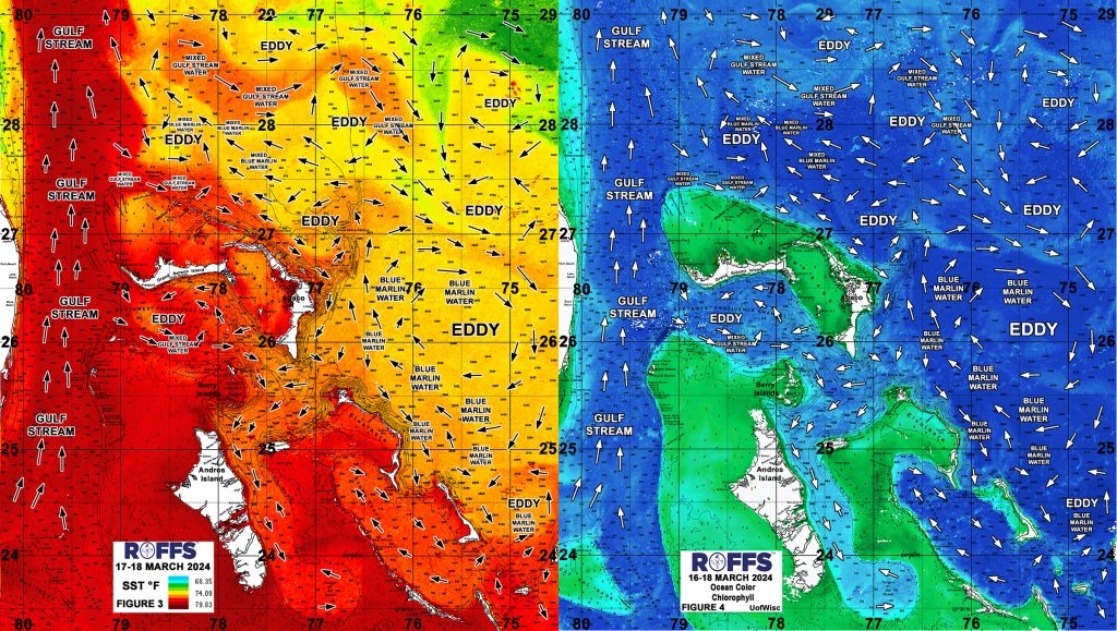
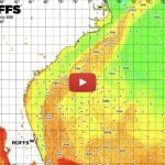
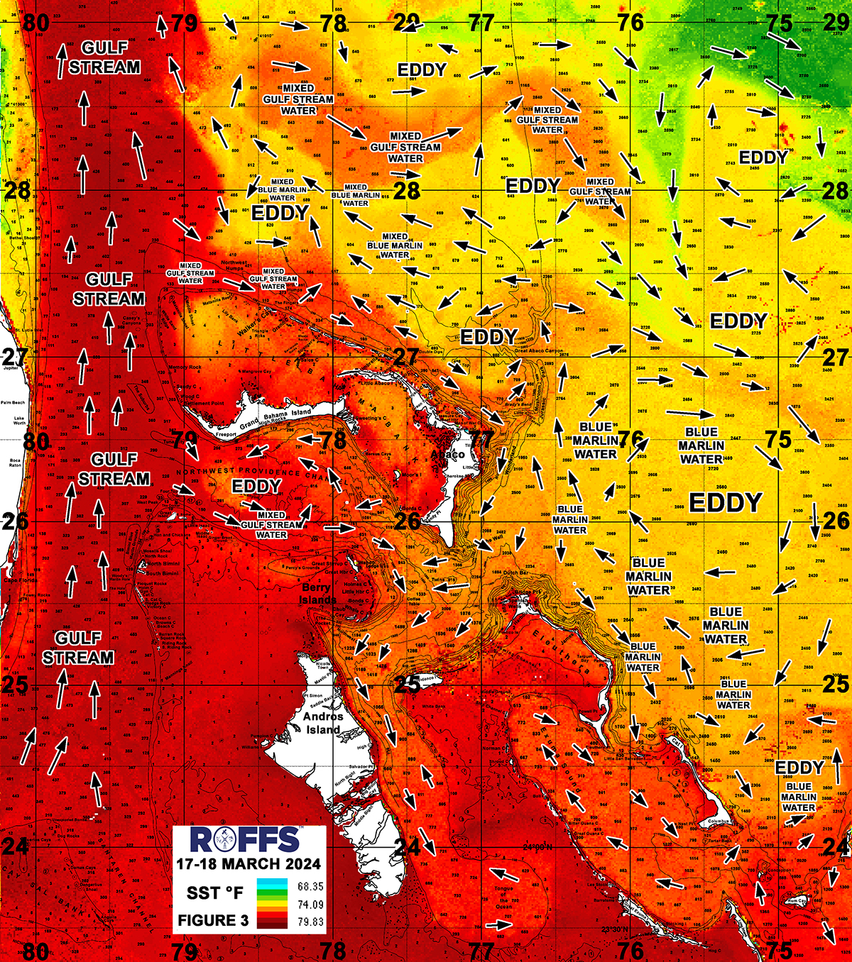
Figure 3: This years conditions were derived from a variety of infrared sensors to get SST from NASA, NOAA, and ESA’s Sentinel 3 satellites during March 17-18, 2024 and Figure 4: Derived from the ocean color/chlorophyll imagery during March 16-18, 2024 from the ESA Sentinel 3 satellites, VIIRS sensors on SNPP satellite in combination with the Aqua and Terra sensor on the MODIS satellites provided by the University of Wisconsin SSEC. We consider this an image pair.
Overall, even though the water is cooler, the marlin fishing appears to be better this time of year than last year as the “blue marlin water” is pushing in a favorable direction into the Wonderland to Little Abaco Canyon area and some of this better water is pushing down between Harbour Island and Abaco towards the Berry Islands and Andros Islands for improved fishing conditions. Furthermore as always, if the wind and water is pushing into the Pocket south and southwest of Chub Cay, it can produce very good fishing action as there has been a few marlin and tuna reported off of Chub Cay. However, the fishing off of Chub has been relatively slow so far this year. Further west we continue to observe the traditional counter-clockwise rotating flow centered in the Northwest Providence Channel now centered directly over Tuna Canyon area. This eddy pulls in Gulf Stream water and interacts with the Island banks and provides good conditions for tuna, dolphin, wahoo and even marlin in this area. Farther north, north of Walker’s Cay and the Abaco Islands, conditions have been changing rapidly, but even with the cooler water and lack of “blue marlin” water in the northern Bahamas, they have been catching marlin and seeing a lot of bait and life. However, the northern Bahamas mahi fishing has been slow so far as there has been a lack of weeds, but more weeds toward Abaco and east of Abaco for mahi.
To back up our ocean observations, there is nothing more valuable than client feedback and reliable fishing reports where we enjoy catching up with our clients and learning what the water conditions are telling us. With that said, we have found further evidence of a possible earlier than normal or certainly earlier and better than last year white marlin, blue marlin and sailfish fishing off of the Abacos to north Eleuthera and also north of Walkers to the Eastern Side of the Gulf Stream. In fact, there is lots of life in the northern Bahamas and the best of it off of Abacos as several boats have caught grand slams recently. If the large eddy stays in the same general location over the next few weeks pushing “blue marlin water” east of Abaco and north, it could be good early season billfishing into April/May. However, it does appear the main flow of the water farther east of Abaco is pushing the cooler water in a southern direction when you get east of 75°30’W. Farther south, off of Cat Island and Long Island to San Salvador Island, the wahoo and yellowfin tuna fishing has been good lately, better than farther north, but the marlin action not as good as the Abaco Islands to Walkers area. In the Chub Cay area, which was GOOD fishing last year as this time, is not as good so far this year.
As the water warms in the coming weeks, we anticipate that there is a good chance that a substantially higher amount of billfish, tuna and other species will continue to be moving closer to the Bahamas Islands. These present conditions look different than last year, but already have indicators of a slightly earlier start to the better fishing action compared to the last few years even though the water is overall cooler. So if fishing action is not good yet near your main Island, stay patient as all signs show that it should improve and warm up. Overall, it sounds like less sargassum this year so far than last year, which may be why mahi fishing has been not as great, but this also makes it easier to fish. ROFFS™ will be monitoring these and other conditions that develop over the next several weeks and months as we do in other areas.
Concluding Thoughts
Based on what we have been observing and hearing in March thus far, the better ocean conditions related to higher abundance of marlin, tuna, and wahoo might have already begun, especially in the northern Bahamas for billfish. The way the eddies have set up this past month has just recently allowed the higher amount of “blue marlin water” to push from southeast to northwest offshore of Long Island to Cat Island to Eleuthera Island and now directly east of Abaco Island and starting a bigger push northwest of Abaco toward Walkers Cay and the Gulf Stream area which is encouraging. Conditions look best right now east of Abaco into the Abaco Canyons and the Wonderland, North Bar, Pocket to Hole in the Wall area for marlin and they have been producing. The reports have hinted at a quicker than normal start to the season especially the northern Bahamas, but the cooler than normal temperatures suggest perhaps a slightly slower start to the season in the other Bahamas areas. We do see a lot of similar features and amounts of “blue marlin water” compared to last year, but the overall SST is cooler than last year and closer to the normal seasonal conditions for this time of year. Overall, we see conditions similar and good in Exuma Sound, but reports of slower than normal fishing in the Berry Islands area. The water continues to look cooler in the eastern Bahamas, but fishing appears to be good, if not better than last year at this same time, especially for billfish in the north, wahoo and tuna further south. Reports suggest that not a lot of dolphin in higher numbers have showed up yet, but that could be because of the cooler SST and lack of weeds in places. We can only hope more dolphin will show up later like they did last year.
We will continue monitoring these ocean conditions within the Bahamas region over the next two months. As these main eddy features and currents progress, the areas of better fishing conditions will change and it depends on where the currents and eddies are pushing over good structure and toward the ledges and banks. Overall, it has already been a GOOD start to the Bahamas fishing season this late winter and spring especially in the Walkers to Abaco areas despite the cooler waters than the past couple of years. Farther south, there is less marlin action (maybe related to lack of effort/reports) but good wahoo and tuna action. With the cooler than normal SST conditions, it could mean a longer more productive overall fishing season especially for billfish as the water will take longer to warm and not get too hot in late May and June and keep a larger population of fish around the Bahamas longer than the previous two years so be prepared to fish consistently until late June in these regions.
In conclusion, it is important to note that good fishing action on a daily basis is strongly linked to local, short-term (24-48 hours) current conditions that concentrate the fish once the preferred habitat of the fish are in a particular region. When the water masses and boundaries of these conditions are stable and favorable, i.e., continuously pushing over good bottom topography and structure then they concentrate the baitfish and larger fish can be found foraging. This means that the fishing action on any given day is controlled by hourly to daily and relatively small-scale (1-10 mile) movements of the currents and their water mass boundaries. Our experience indicates that to reliably forecast specific concentrations of fish on a daily basis, one must evaluate the ocean conditions on these scales. Relatively small subtle changes in the currents and their boundaries often have dramatic effects on the distribution and concentration of fish. Contact ROFFS™ for these daily detailed fishing forecasting analyses and get the inside track to where the better conditions will be tomorrow. We highly recommend when the weather permits, that you prepare now for the spring Bahamas fishing season and other fun fishing action as the conditions and fishing action is already good in some places and should improve over the next few weeks as the water warms and larger amounts of “blue marlin” water works its way north to northwestward.
Stay safe and tuned in to ROFFS™ on our web site www.roffs.com, on Facebook/Instagram @roffsfishing or subscribe to our newsletter for additional news and reports related to where the better conditions for fishing action is occurring each week. Thank you for your continued support.
Safe and Successful Fishing from ROFFS™