ROFFER’S OCEAN FISHING FORECASTING SERVICE, INC. TOLL FREE 800 677-7633 & (321) 723-5759 // WWW.ROFFS.COM
ROFFS™ FISHERIES OCEANOGRAPHIC ANALYSIS (LAT./LONG.) FOR THE HUDSON CANYON TO THE NORFOLK CANYON OFFSHORE
UPDATED ON SAT. 14 DECEMBER 2013 FOR SAT. P.M. & SUN. FISHING ONLY
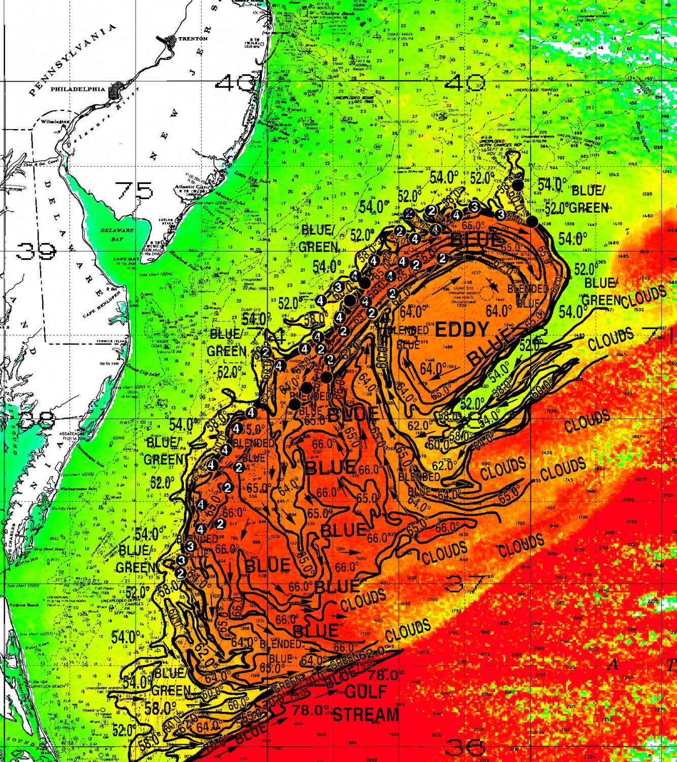
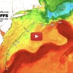
Based on a multiple factor analysis, the symbols (hot spot dots) mark the areas where bait concentrations are expected and where fishing action are expected to be better compared with other (nonmarked) areas. These are not based on dock rumors or hearsay fishing reports. Fishing reports are stated as such. You should start fishing where you recognize other signs of good fishing conditions near these marked areas (weed lines etc.). It is very important to use your sea surface temperature (sst°) gauge to locate the boundaries of the water masses, which are outlined. Please keep in mind that we use a combination of NOAA buoys to calibrate our daily SST each morning. Therefore, rather than trying to find water based on the absolute temperature values shown on the map, search for the relative change in sst where the water mass boundaries occur. Arrows indicate the main current direction. Numbers inside of the dots indicate the number of consecutive days that we have seen favorable conditions in that location (1 fathom equals approximately 6 feet). Noon to afternoon SST may be 1°F or greater than the morning calibrated SST on the analysis charts.
We were able to use yesterday afternoon and today’s infrared SST imagery data, along with yesterday’s MODIS ocean color/chlorophyll imagery, to increase your chances for tuna, swordfish, dolphin, billfish and wahoo action. The Gulf Steam is present in the analysis area, with a morning sst of 78.0°F. Overall, a relatively large, clockwise rotating Gulf Stream eddy, that was previously providing good fishing action over Hudson Canyon, has moved southwards, creating favorable conditions for tuna, sailfish, mahi, swordfish, dolphin and wahoo action from over Toms Canyon to over Spencer Canyon. Due to the Gulf Stream eddy’s oval shape, it is expected to push inshore over Carteret Canyon to Spencer Canyon, enhancing the good conditions already there. From Poor Mans Canyon to Norfolk Canyon, a filament of blended blue water from the Gulf Stream eddy is pushing southwards, suggesting good chances for tuna, sailfish, mahi, swordfish, dolphin and wahoo action along the southwestern canyon walls.
With this in mind, good chances for fishing action occurs along the blue green to blue 7°F western boundary of the Gulf Stream eddy (58.0°F-65.0°F), which flows northeastwards over Toms Canyon, over 35-50 fathom depth near Poor Mans Canyon near 73°43’W & 38°25’N, to north of Carteret Canyon over 50 fathom depths near 72°45’W & 39°05’N (all favorable, yet different, for four days). If you fish out here, don’t miss out on the areas between these canyons where the blue green to blue 7°F Gulf Stream eddy boundaries (58.0°F-65.0°F) have been favorable, yet different, for four days, over 35-50 fathom depths near 73°37’W & 38°30’N, to over 40 fathom depths near 73°28’W & 38°35’N, to over 40 fathom depths near 73°13’W & 38°56’N, and 50 fathom depths near 72°55’W & 39°05’N. These boundaries are expected to be enhanced as the southern portion of the Gulf Stream eddy pushing inshore. If fishing action along these boundaries is slower than you would like, move further offshore, to where the inner blue 1°F water mass boundary (65.0°F-66.0°F) of the Gulf Stream eddy suggests good chances of fishing action over 50 fathom depths near 73°15’W & 38°40’N, to near 73°04’W & 38°50’N, and near 72°58’W & 38°55’N (also all favorable, yet different, for four days). On your way offshore, take a look over the 35 fathom good bottom structure near 73°38’W & 38°40’N, and over 38 fathom depths near 73°28’W & 38°52’N (also favorable, yet different, for four days), where a filament of blue green to blended blue 6°F water mass boundaries (54.0°F-60.0°F) suggests good chances of fishing action.
Between Spencer Canyon and Poor Mans Canyon, the water is being pulled offshore. However, a filament of blended blue 6°F water (60.0°F-65.0°F) from the Gulf Stream eddy is pushing southwards, suggesting good chances for fishing action along the southwestern canyon walls, over 40-50 fathom depths near 74°08’W & 38°03’N, to near 74°15’W & 37°58’N, as well as near 74°20’W & 37°48’N, to near 74°26’W & 37°43’N (all favorable, yet different, for four days). Additional chances for good fishing action occur south, over 30-100 fathom western walls over Washington Canyon near 74°30’W & 37°30’N, to over 60-100 fathom depths near 74°30’W & 37°20’N (both favorable, yet different, for four days), where a blended blue 1°F water mass boundary (64.0°F-65.0°F) occurs.
Verbal updates are free between 10:30 AM and 11:59 AM (eastern time) only, please call. Thank you for not sharing this analysis with non-paying fishermen. We survive on your honesty. ROFFS™ fall hours: Mon.-Fri. 9:00 AM to 5:00 PM, Saturday CLOSED. Have a happy holiday season, and a healthy and successful New Year. ROFFS™ will be closed December 25, 2013 and January 01, 2014. Remember you can order and/or purchase your fishing analyses from our website (https://roffs.com/ and click on Order Analyses button) or by email.