ROFFS™ has received numerous calls requesting information on the distribution and movements of the Mississippi River water in the open ocean and on coastal areas following the recent floods and resulting water discharge into the Gulf of Mexico. Several oceanographers from the private industry (Ken Schaudt of Schaudt.US), universities (Frank Muller-Karger: Univ. of South Florida Institute for Marine Remote Sensing, Nick Shay and Jerry Ault Univ. Miami RSMAS, George Maul, Florida Institute of Oceanography), and government (Gustavo Goni, Michelle Wood NOAA/AOML), who have been working in collaboration since the Deepwater Horizon oil spill incident last summer, are now working together to monitor the riverine water that has been moving into the offshore waters in the Gulf of Mexico.
The investigation of the transport of the Mississippi river waters into the Gulf of Mexico and areas beyond is important because the these river waters carry with them farm chemicals that may result in creating a large dead zone in the Gulf of Mexico. These dead zones are induced by nitrogen and phosphorus from crop fertilizers, which fertilize algae once they reach the Gulf and create lack of oxygen, which may kill other living organisms. The collaborative work being carried by these scientists will allow for advances in many aspects related to mapping, monitoring, and modeling water flow and the possible fate of pollutants in the Gulf of Mexico and elsewhere, and to investigate possible links between extreme amounts of water river discharges and living organisms. ROFFS™ also continues to work with recreational and commercial fisheries on verifying the color, distribution, and flow of the river water and to provide on-site validation of what we are observing from the satellites.
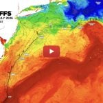
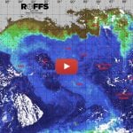
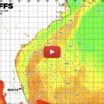
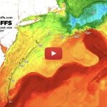
Similarly to what some members of this team did last summer, ROFFS™ is providing a satellite image and a brief analysis of the upper ocean Gulf of Mexico conditions. Below is an eight day composite image derived from the NASA ocean color imagery from the MODIS sensor on the Aqua satellite with data from July 10-17, 2011; that has been to roughly approximate the color of the water and to distinguish among the different types of waters present in the region: blue, green, and brown. We have compared data from several satellite sources, such as infrared, ocean color, and altimetry, to better understand the complexity of the ocean flows. It is beyond the scope of this note to debate whether or not there is a main, totally enclosed and separated Loop Current eddy in the northern Gulf of Mexico centered near 89°00”W & 27°00’N or a very elongated Loop Current that is being pulled around this feature and then southwestward toward the Florida Keys. However, we hope to learn more about the Gulf circulation below the surface after Nick Shay from the Univ. Miami RSMAS deploys instruments into the Loop Current as part of an airplane oceanography research program to measure heat capacity for hurricane intensification. We will also use data from other researchers (e.g. Mississippi State Univ., Univ. Colorado, Univ. South Florida, NOAA and others) as it becomes available.
Of particular interest is the discolored water southwest of Tampa, FL, where there is a substantial counter-clockwise flowing exaggerated Loop Current frontal eddy with discolored fresh water that is composed of water that was observed leaving the Mississippi River and nearby coastal areas several weeks ago. While this water is slowing moving in a southward direction overall, this motion has been much slower than expected, due in part to the enlarged size of the frontal eddy water mass. Also of note is the “spike” shaped discolored (show as brown) water that is being pulled by the Loop Current from the Mississippi delta area in a east-southeastward direction to approximately 97°00’W & 28°30’N and then southward to at least as far as 97°30’W & 26°30’N. It remains to be seen where this water will travel and particularly interested to see if circles the feature centered near 89°00”W & 27°00’N as mentioned above.
Please click on image below to view larger in a new window.