Please click on the images below to view them larger and in a new window.
19 AUG 2009 – Hudson to Baltimore Full Analysis – LAT./LONG.
19 AUG 2009 – Wilmington to Norfolk Full Analysis – LAT./LONG.
2009 Mid-Atlantic $500,000 Large Scale Analysis- LAT./LONG.
19 AUG 2009 – Hudson to Baltimore Full Analysis – LORAN
19 AUG 2009 – Wilmington to Norfolk Full Analysis – LORAN
2009 Mid-Atlantic $500,000 QuickTime™ Movie of Ocean Conditions
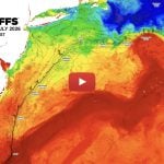
August 19, 2009 ROFFS™ Hudson to Baltimore Area – Sea Surface Temperature (SST°)

ROFFS™ FISHERIES OCEANOGRAPHIC ANALYSIS
FOR THE HUDSON CANYON TO BALTIMORE CANYON OFFSHORE (LAT./LONG.)
UPDATED ON WED. 19 AUG. 2009 FOR WED. PM & THURS. FISHING ONLY
Based on a multiple factor analysis, the symbols (hot spot dots) mark the areas where bait concentrations are expected and where fishing action is expected to be better compared with other (non-marked) areas. These are not based on dock rumors or hearsay fishing reports. Fishing reports are stated as such. You should start fishing where you recognize other signs of good fishing conditions near these marked areas. It is very important to use your sea surface temperature (sst°) gauge to locate the boundaries of the water masses, which are outlined. Rather than trying to find water based on the absolute temperature values shown on the map, search for the relative change in sst where the water mass boundaries occur. Arrows indicate the main current direction. Numbers inside of the dots indicate the number of consecutive days that we have seen favorable conditions in that location. Broken lines (small dotted lines) are water mass boundaries detected from the ocean color (chlorophyll + colorized dissolved organic material or “CDOM”) satellite data. AFTERNOON sst are likely to warm 2°-3°F than shown here.
We used a combination of last night’s and this morning’s infrared (sst) data and yesterday afternoon’s visible – ocean color data for today’s analysis. This afternoon was too cloudy to provide useful satellite data. We are providing both the sst and ocean color graphic today derived from both the U.S. and European satellites. We have adjusted our estimates of the sst of the water to reflect the sst we anticipate that you will encounter at first light. The Gulf Stream eddy continues to circulate dark blue Gulf Stream water 78.2°F – 79.0°F in a clockwise direction. The water from Carteret Canyon to the Hudson Canyon appears to be moving northeastward while the water over the deeper parts of Wilmington Canyon to the Washington Canyon appear to be moving southward. It was not obvious how the water was flowing over the main parts of the Lindenkohl Canyon and Spencer Canyon. Some of the water along the western side of the Wilmington Canyon is moving southward. The eastern side of the Wilmington Canyon to the Lindenkohl Canyon may be experiencing some westward push of the water that occurs along the southwestern side of the eddy as it is turning westward now.
Over the Hudson Canyon area there still are favorable conditions over the west side from the 100 fathom curve south of the Elbow ( 72°18’W & 39°33’N) to the 100 Square area (72°12-10’W & 39°32’N) where there are favorable water mass boundaries and color changes. These conditions are declining, but good fishing action is likely to continue for approximately another 24 hours. The 500 fathom tip still has favorable conditions. Over the Toms Canyon area good chances for fishing action continue over the 50- 100 fathom depths (72°46’W & 39°10’N to 72°43’W & 39°10’N) as the favorable water mass boundary (6th consecutive day) and water color change exists even though the water is moving northeastward which actually is favorable for the tip of the canyon. Additional good chances for fishing action occur over the 70-80 fathom depths ( near 72°37-30’W & 39°15-17’N). The northeastern flow of the water mass boundary north of the Carteret Canyon is not favorable, but some fishing action is likely over the 100 – 250 fathom depths (near 72°48’W & 39°01’N). Over the Lindenkohl Canyon area the more favorable conditions occur over the 40 fathom lumps (centered near 73°10’W & 38°52’N) where favorable water mass boundary (4th day) and color changes suggest that there is a good chance for fishing action with marlin, tuna and dolphin. Additional chances for some action are suggested by the conditions over the 30 fathom curve by the Lobster Claw (near 73°30’W & 38°54’N) and 35 fathom depths (near 73°25’W & 38°50’N).
Over the Spencer Canyon area we have had favorable water mass boundary conditions for the last three days over 60-100 fathom depths (near 73°17’W & 38°33’N) along with a color change (blue-green to blue). It appears that this area is most likely to start to realize the effects of the eddy rotation sometime Thursday afternoon which is likely to continue over the next few days. Additional improved chances for action occur southwest over the 70-100 fathom depths (near 73°22’W & 38°27’N). The westward push of the water should also enhance the chances for some fishing action over the Spencer Canyon and perhaps the Wilmington Canyon. The improvement along the west side of the Wilmington Canyon will occur until the blue water moves there over the next few days perhaps first near 73°28-30’W & 38°33-31’N. Inshore of the Wilmington Canyon the chances for fishing action are good over the 30 fathom lump (near 73°41’W & 38°38’N). Over the Baltimore Canyon the blue water has been slowly moving southward, but a favorable water mass boundary (4th consecutive day) and color change suggests that good chances for fishing action occurs over the 500 fathom curve particularly near 73°50’W & 38°00’N, but also to 73°56’W & 37°25’N. If the westward push of water is realized in this area tomorrow, then this area will provide very good chances for fishing action. You should start over the 100 fathom curve and work offshore. The Vries Canyon (near 73°42’W & 38°06’N) will also increase your chances for some fishing action. Offshore it remains to be seen what the effect of the arrival of the blue-green water over the 1000 fathom curve near Rusty’s Spot (near 73°2’W & 38°04’N) will be. In other areas, the blue-green water brings inshore baitfish to the offshore blue water and results in a concentration of marlin, tuna and dolphin. If you head offshore to the 1000 fathom curve, but sure to check the three sea mounts (centered near 73°36’W & 38°03’N) as there has been blue water over the offshore areas all week.
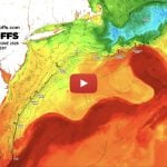
August 19, 2009 ROFFS™ Wilmington to Norfolk Area – Sea Surface Temperature (SST°)
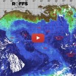
August 19, 2009 ROFFS™ Wilmington to Norfolk Area – Ocean Color/Chlorophyll


ROFFS™ FISHERIES OCEANOGRAPHIC ANALYSIS
FOR THE WILMINGTON CANYON TO NORFOLK CANYON OFFSHORE (LAT./LONG.)
UPDATED ON WED. 19 AUG. 2009 FOR WED. PM & THURS. FISHING ONLY
Based on a multiple factor analysis, the symbols (hot spot dots) mark the areas where bait concentrations are expected and where fishing action is expected to be better compared with other (non-marked) areas. These are not based on dock rumors or hearsay fishing reports. Fishing reports are stated as such. You should start fishing where you recognize other signs of good fishing conditions near these marked areas. It is very important to use your sea surface temperature (sst°) gauge to locate the boundaries of the water masses, which are outlined. Rather than trying to find water based on the absolute temperature values shown on the map, search for the relative change in sst where the water mass boundaries occur. Arrows indicate the main current direction. Numbers inside of the dots indicate the number of consecutive days that we have seen favorable conditions in that location. Broken lines (small dotted lines) are water mass boundaries detected from the ocean color (chlorophyll + colorized dissolved organic material or “CDOM”) satellite data. AFTERNOON sst are likely to warm 2°-3°F than shown here.
We used a combination of last night’s and this morning’s infrared (sst) data and yesterday afternoon’s visible – ocean color data for today’s analysis. This afternoon was too cloudy to provide useful satellite data. We are providing both the sst and ocean color graphic today derived from both the U.S. and European satellites. We have adjusted our estimates of the sst of the water to reflect the sst we anticipate that you will encounter at first light. As best as we can determine the water over the deeper parts of Wilmington Canyon to the Washington Canyon appear to be moving southward. It was not obvious how the water was flowing over the main parts of the Spencer Canyon. Some of the water along the western side of the Wilmington Canyon is moving southward. The Spencer Canyon to the eastern side of the Wilmington Canyon may be experiencing some westward push of the water from offshore due to the rotation of the eddy toward the New Jersey and Delaware coastlines. The southwestern side of the eddy is turning westward now. Over the Spencer Canyon area we have had favorable water mass boundary conditions for the last three days over 60-100 fathom depths (near 73°17’W & 38°33’N) along with a color change (blue-green to blue). It appears that this area is most likely to start to realize the effects of the eddy rotation sometime Thursday afternoon which is likely to continue over the next few days. Additional improved chances for action occur southwest over the 70-100 fathom depths (near 73°22’W & 38°27’N). The westward push of the water should also enhance the chances for some fishing action over the Spencer Canyon and perhaps the Wilmington Canyon. The improvement along the west side of the Wilmington Canyon will occur until the blue water moves there over the next few days perhaps first near 73°28-30’W & 38°33-31’N. Inshore of the Wilmington Canyon the chances for fishing action are good over the 30 fathom lump (near 73°41’W & 38°38’N). Over the Baltimore Canyon the blue water has been slowly moving southward, but a favorable water mass boundary (4th consecutive day) and color change suggests that good chances for fishing action occurs over the 500 fathom curve particularly near 73°50’W & 38°00’N, but also to 73°56’W & 37°25’N. If the westward push of water is realized in this area tomorrow, then this area will provide very good chances for fishing action. You should start over the 100 fathom curve and work offshore. The Vries Canyon (near 73°42’W & 38°06’N) will also increase your chances for some fishing action. Offshore it remains to be seen what the effect of the arrival of the blue-green water over the 1000 fathom curve near Rusty’s Spot (near 73°2’W & 38°04’N) will be. In other areas, the blue-green water brings inshore baitfish to the offshore blue water and results in a concentration of marlin, tuna and dolphin. If you head offshore to the 1000 fathom curve, but sure to check the three sea mounts (centered near 73°36’W & 38°03’N) as there has been blue water over the offshore areas all week.
There is a filament of blue water over the eastern side of the Rock Piles that may provide some fishing action if the conditions remain stable overnight. More favorable conditions occur over the eastern side of the Washington Canyon from the 40 fathom depths (near 74°29’W & 37°31’N) to the 100 fathom curve (near 74°28’W & 37°27’N). The 100 fathom curve has had relatively favorable conditions the last three days suggesting that good chances for fishing action occurs. Additional chances for fishing action are suggested by the blue water to green water mass boundary west of the tip of the Washington Canyon to 30 fathom depths (near 74°40’W & 37°27’N) if the southwest winds prevent the green water from moving southward.
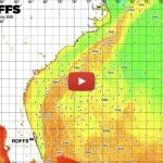
Over the Norfolk Canyon area the blue water to green water mass boundary was productive yesterday with white and blue marlin. Good chances for fishing action occurs over the southeastern side of the Norfolk Canyon over the 100-500 fathom depths (near 74°40-35’W & 36°55’N) along the green to blue water mass boundary that has been seen for the last four days. Additional good chances for fishing action occur over the 100-500 fathom depths near 74°37-35’W & 37°00’N. Additional chances for fishing action also are suggested by the color change and water mass boundary (near 74°40’W & 37°06’N). ROFFS™ Special Large Area – Sea Surface Temperature (sst°)
August 18, 2009  ROFFER’S OCEAN FISHING FORECASTING SERVICE, INC.
TOLL FREE 800.677.7633 & (321) 723-5759 // 24 HR FAX (321) 723-6134//[email protected]
ROFFS™ FISHERIES OCEANOGRAPHIC ANALYSIS
FOR THE MID-ATLANTIC REGION UPDATED ON TUES. 18 AUG. 2009
The skies were very clear today so we are taking this opportunity to show a regional view that is not as big as the one sent Sunday but extends from the northern tip of the eddy to the waters east of North Carolina. Note that the eddy is not symmetrical and more egg-shaped and that the orientation is north – south. The southern side of the eddy is now hitting the Gulf Stream which may slow the rotation of water circulating clockwise around the eddy. This is important because when the eddy rotates further the southern side will be moving toward the Delaware – New Jersey coast and will push the water into the canyons which is a favorable motion that is usually associated with improved fishing action. It remains to be seen when the effect of this rotation will be realized in this fishing area, but it appears likely to start at the end of the week, perhaps as early as Thursday, but more likely Friday – Sunday. The Baltimore Canyon, Wilmington Canyon and Spencer Canyon areas should experience the stronger push of water into the ledges. The complicating factors now include how much of the rotation of the southern side of the eddy will be slowed by the Gulf Stream interaction and if the eddy become more compact delaying the push of the water westward. Presently most of the blue water from the Carteret Canyon to the Baltimore Canyon is meandering in a southwest direction, mostly parallel with the bottom depth contours with a minimal push into the tips of the canyon areas. The result is that fishing action is sporadic and spread over a wide area with the overall catch rate relatively slow. Over the Toms Canyon and Hudson Canyon the water is being pulled in a northeastward – offshore direction which usually is not associated with good fishing action except for the eastern sides of the canyon wall when there has been a stable water mass boundary like the east wall of the Hudson Canyon.
Note that there are no large filaments of new Gulf Stream water moving toward the Norfolk Canyon or Washington Canyon areas suggesting the fishing action is likely to remain associated with blue-green to blue water or green to blue-green water mass boundaries.
There is blue (79°-80°F) water from the Hudson Canyon to the offshore areas of the Washington Canyon and Norfolk Canyons. If you have any special areas (ledges, deep water wrecks, sea mounts, etc.) that have been productive for you under similar blue water conditions, then you should consider fishing these areas to catch the one big fish to bring to the weigh master.
Based on the weather information we receive from NOAA and elsewhere, it appears that the weather will be favorable for at least the next two days and probably through the end of the week. Hurricane Bill is forecast to be in the area of Bermuda Saturday morning and thus, is not expected to produce bad weather for fishing in this area based on the present information. We expect that there will be a rolling swell from this storm in the offshore waters. It remains to be seen how soon the surf will increase along the New Jersey coast. Also today we will be sending a Quicktime movie via email showing the rotation of the eddy.
The bottom line: we think you should wait at least a day or two before fishing your last day of the tournament.