Please click on the images below to view them larger and in a new window.
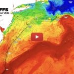
August 2, 2009 ROFFS™ Sea Surface Temperature (SST°)
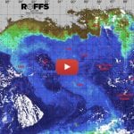
August 2 , 2009 ROFFS™/USF_IMaRS MODIS Ocean Color/Chlorophyll


ROFFS™ FISHERIES OCEANOGRAPHIC ANALYSIS
FOR OCEAN CITY WHITE MARLIN OPEN
UPDATED ON SUN. 02 AUG. 2009 FOR SUN. P.M. & MON. FISHING ONLY
We are providing this regional scale overall oceanographic analysis for our clients that had the foresight to order both of our analysis areas or have subscribed to our cost effective Unlimited Analysis Plans. We thank you for your support. For the color email we are providing the enhanced infrared satellite image for sea surface temperature (sst) and ocean frontal analysis and the ocean color satellite image for ocean color, turbidity and index of plankton – colorized dissolved organic matter. These were derived from satellite data the last three days to help eliminate most of the clouds that have been moving rapidly through this area. The data are derived from the United States (NOAA, Terra, Aqua) and European (MetOp and Envisat) satellites. For those receiving this via fax we have only provided the ocean frontal and circulation analysis derived from the infrared (sst) data.
The two ocean features dominating the ocean currents in this region are the Gulf Stream and the clockwise rotating eddy (southeast of Long Island, NY) centered approximately near 71°15’W & 39°15’N. This is an egg-shaped eddy which has been shedding bands of blue water faster than the usual eddy of it size. This is due in part to the unstable/unbalanced circulation as a result of interactions with the Gulf Stream and another similar sized eddy east of it (not shown). Other than the blue Gulf Stream water over the 100 fathom curve between the Toms Canyon and the Hudson Canyon, there is no concentrated Gulf Stream water over the 100 fathom curve in this region. There are water masses with a mixture of Gulf Stream blue water and coastal water, commonly called “blended blue water”, over the offshore areas from Carteret Canyon to the Washington Canyon. The filament of blue water between the Spencer Canyon and the Wilmington Canyon is bluer and clearer than the rest of this water. This blue water filament was pushed westward from the eddy a week ago and has rapidly moved in a southwestward direction all week even though there was 15-20 mph winds from the southwest and a northeastward pull by the eddy. In addition there is a counter-clockwise flow of the water south of it. However, this water continues to move in a southwest direction. This blue water is expected to give a pulse of fishing action over the Wilmington Canyon the next few days.
The northern boundary of Gulf Stream water that has been pulled northward by a counter-clockwise rotating eddy east of Oregon Inlet is over the 1500 fathom depths of the Norfolk Canyon. It remains to be seen if this eddy (centered near 74°15’W & 35°45’N) will move northward or northeastward. If the eddy moves more northward it will bring more Gulf Stream water toward the Norfolk Canyon that presently is covered by turbid green water.
The winds from the southwest continue to push green turbid water in an east – northeastward direction which is unfavorable for good fishing action to develop. The result is likely to be that the coastal green and blue-green water will move northeastward. It remains to be seen where the boundary of the coastal blue-green and the blue water will form between the Baltimore Canyon and Wilmington Canyon areas. Once stabilized this boundary is likely to provide good fishing action as long as the conditions remain relatively stationary.
Good luck and we will provide another of these analyses when the conditions permit and when it is appropriate to do so. Safe and successful fishing.
DO NOT FORGET THAT YOU CAN CALL BETWEEN 10:30 AM AND 11:59 AM FOR FREE VERBAL UPDATES. WE WILL KEEP YOUR INFORMATION CONFIDENTIAL AS WE HAVE FOR THE LAST 22 YEARS. Thank you for not sharing this analysis with non-paying fishermen. We survive on your honesty.