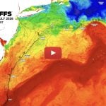
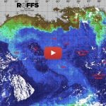
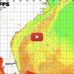
We have observed some noteworthy oceanographic conditions in the northern Caribbean Sea, eastern Gulf of Mexico and Florida Keys area during July 15-17, 2009 that are continuing. We are providing two color enhanced satellite images derived from the infrared for sea surface temperature (colorized with yellow and red with the red being the warmest) and ocean color (purple, blue, green and brown). The infrared images were derived from both NOAA and NASA polar orbiting satellites and the ocean color from the NASA Aqua satellite (MODIS sensor). Look the images on pages 2 and 3. There is a relatively large Loop Current eddy in the Gulf of Mexico that appears with an estimated sea surface temperature (SST) 87°F. This eddy has a distinctive deep blue-purple color in the ocean color imagery. Note that the water in the Yucatan Strait (between the Yucatan Peninsula and Cuba) and the Straits of Florida is two degrees cooler (85°F) than the water in the Gulf of Mexico. This is an unusual event. Due to the newly formed Loop Current eddy, the Loop Current has a minimum “Loop” or has no Loop in that the Yucatan Current flows directly into the Florida Keys to form the Florida Current without significant intrusion into the Gulf of Mexico. This direct flow is obvious in both the infrared (SST) and ocean color data. Also note the many interesting features in the ocean color imagery surrounding Cuba which once again demonstrates the importance of ocean color satellite imagery and that infrared satellite imagery is useful in the summer months in this region.
While observing the flow over several days we have noted that there appears to be a minimal amount of water from the Gulf of Mexico entering the Florida Keys. It will be interesting to learn what the effects of this is on the ecosystem in the Florida Keys.
The satellite imagery were derived from data that we download from NOAA satellites and the University of South Florida IMaRS.
Please click on the images below to view them larger and in a new window.
ROFFS™/USF_IMaRS Sea Surface Temperature (SST°) July 15-17, 2009
ROFFS™/USF_IMaRS MODIS Ocean Color/Chlorophyll July 17, 2009


ROFFS™/USF_IMaRS Sea Surface Temperature (SST°) with current flow arrows July 15-17, 2009
ROFFS™/USF_IMaRS MODIS Ocean Color/Chlorophyll with current flow arrows July 17, 2009