Originally published: October 23, 2015 | Article courtesy: www.jpss.noaa.gov | Please click here for original article.
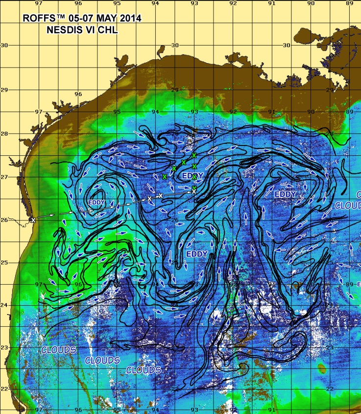
Above: Oceanographic analyses including ocean color from Visible Infrared Imaging Radiometer Suite (VIIRS). Credit: Roffer’s Ocean Fishing Forecasting Service, Inc. (ROFFS™)
Did you know that satellite data products from the Joint Polar Satellite System (JPSS) Program are helping scientists study Atlantic bluefin tuna larval ecology? NOAA’s National Marine Fisheries Service (NMFS) uses satellite observations such as topography, sea surface temperature, and ocean color in their studies of highly migratory fish species like the bluefin tuna. Bluefin tuna is one of the most highly evolved fish species and is in danger of overfishing. Prized as sushi, one bluefin tuna can sell for tens of thousands of dollars.
Satellite data has helped researchers gain a better understanding of the migratory patterns of the bluefin tuna. This information assists researchers in understanding the spawning patterns and life cycle, and is used to formulate policies to help prevent overfishing. JPSS data products are an important asset to monitoring and protecting the oceans’ ecosystem and global economy by providing timely and high quality data for decision support through significant technological and scientific advances.
NMFS participated in two consecutive 4-year studies in the Gulf of Mexico and Northern Caribbean focusing on the larval ecology of the Atlantic bluefin tuna, in relation to environmental conditions and climate.
During a recent cruise on board the NOAA Ship Nancy Foster from April 27- June 5, 2015, NOAA’s Center for Satellite Applications and Research (STAR) team members, Mengua Wang and Lide Jiang, provided near-real-time data from JPSS’ Visible Infrared Imaging Radiometer Suite (VIIRS) instrument to Dr. Mitchell Roffer, founder of Roffer’s Ocean Fishing Forecasting Service, Inc. where the satellite data was integrated into daily oceanographic analyses that included sea surface temperature and color, water mass identification, current direction and relative speed and ocean frontal boundaries to guide the shipboard sampling strategy sent to Dr. John Lamkin of NMFS’ Southeast Fisheries Science Center and helped determine if it was necessary to change the location of the sampling stations to increase the chances of finding bluefin tuna larvae.
“This data allows the research team to be able to model how habitats might change in the next 100 years. Their work would not be possible without satellite data,” said Dr. John Lamkin, NMFS Team Leader for the Early Life History Laboratory. “These models will aid in creating reliable forecasting of tuna habitats and give researchers and decision-makers better tools for understanding living ecosystems and are invaluable to fisheries oceanography research.”
In addition to aiding in oceanographic studies, JPSS delivers key observations for the Nation’s essential products and services, including forecasting severe weather like hurricanes, tornadoes, and blizzards days in advance, and assessing environmental hazards such as, droughts, forest fires, poor air quality and harmful coastal waters, helping to secure a more “Weather-Ready Nation.”
To learn more about these efforts by the National Marine Fisheries Service (NMFS), visit www.nmfs.noaa.gov and visitwww.jpss.noaa.gov to experience the science behind the satellites.


