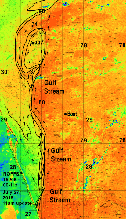
If you are flying to look for the lost teenagers (Austin and Perry), here is a map of the Gulf Stream (outlined). The black dot is approximately where the boat was found yesterday. IF the teens swam west from a location near Jupiter and then were pulled north they would likely be along the western boundary of the Gulf Stream like any floating object. IF they were on the western side of the Gulf Stream in a filament of Gulf Stream water, which seems likely and IF they were on the western boundary of the current, this could mean that they would not be as far north as the boat because the boat was probably in the higher speed core of the current moving north faster than one would be along the western bounder of the Gulf Stream. BUT there is no real way to test this now. But searching between 28°30’N and 29°30 north along the western boundary of the Gulf Stream (approx. 80°W between 28°00 and 28°45’N) is as good a guess as possible under the known circumstances. North and west of where they found the boat try 80°15’N between 29°00’N and 29°45’N. A big complication is that the winds were mostly from the west-southwest yesterday and Saturday along the Space Coast. They may not have felt strong along the beach, but a mile offshore they were a good 15 knots.
Much better view and trace of the Gulf Stream update at 11 am after reviewing all the morning satellite imagery. Again IF Austin and Perry made it to the western boundary of the Gulf Stream and the convergence is keeping them there, then the outlines provides some insight on where one should be searching. There is a large eddy offshore of Jacksonville, FL centered near 80°15’W & 30°30’N that could pull them first northeastward but near 80°00’W & 30°25’N the current will pull them westward and southward.