Originally Published: July 15, 2015 | By: Chris Bonanno/Florida Today | Please click here for original article.
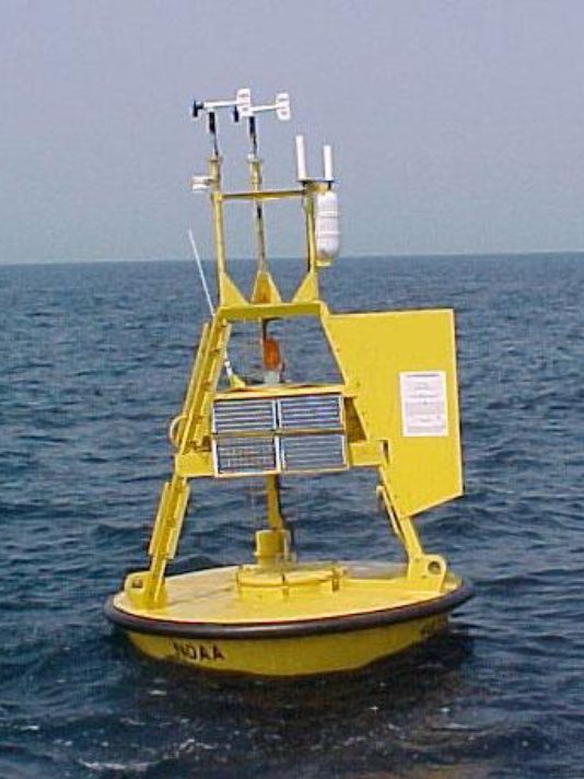
Above: The Station 41010 buoy, 120 nautical miles east of Cape Canaveral, is one of two buoys slated to be removed in the spring.(Photo: NOAA)
The imminent removal of a pair of buoys east of Cape Canaveral has locals deeply concerned about the future of hurricane and fishing forecasts.
Both buoys from NOAA’s National Data Buoy Center, Station 41009, 20 nautical miles east of Cape Canaveral, and Station 41010, which is 120 nautical miles east in the Atlantic Ocean, are slated to be taken offline in the spring. The buoys provide a bevy of information on air and water conditions, including wind direction and speed, air and water temperature, wave heights and barometric pressure.
The buoys had been funded primarily by NASA with a small portion of the financial support also being given by the Air Force, according to George Diller, NASA public affairs information specialist.
They were first put into place, he added, with the beginning of the shuttle program and they were used to help crews recover booster rockets from the shuttle, but as the shuttle program has ended, so has the funding from the organization.
“Unfortunately it’s just a casualty of the end of the shuttle program as well because those were just assets,” said Diller.
News of the buoys’ fate was not sitting well with a number of interests along the Space Coast.
Dr. George Maul, a professor of oceanography at Florida Tech, is a member of SECOORA, the Southeastern Coastal Ocean Observing Regional Association, one of 11 in the United States. He says that loss of the buoys hurts prospective ocean and meteorological forecasts, “particularly for tropical storms for the east coast of Florida.”
“We have very few data points on the east coast of Florida,” he added.
To that end, SECOORA will ask NOAA to help fund the buoys.
“These two buoys are in the SECOORA footprint so we are going to write a letter from SECOORA to NOAA arguing based on scientific reference and documentation that the effect of removing these two buoys will be substantial,” added Maul.
The news has also rankled fishing interests in Port Canaveral.
“There’s a lot of us that use that to check on local sea conditions and things of that nature,” said Mike Rigby, who fishes for red snapper and grouper and is also a boat driver with the Canaveral Pilots Association. “It’s a good indicator to see what the offshore forecast is and the seas and so forth and to lose that, it would be the loss of another tool to keep tabs on the marine forecast here. People have relied on that for many, many years. We’ve all become accustomed to it here. It’s a shame to lose it.”
“It would create a problem with wasting a lot of people’s time, so to speak,” said Stephen Knowles, captain of Sea Leveler Sport Fishing Charters. “…It would definitely be less efficient. We would turn around and come back because it would be rough to go fishing where if the buoys were there, I’d look it up like the first time I do every morning, I’d look at the buoy,”
There is still hope that the buoys could be saved. NASA has notified a number of organizations that the funding is ending, Diller say, including the U.S. Coast Guard, National Weather Service, 45th Weather Squadron and a number of commercial launch service providers, among others, in the hopes of finding a source or sources of funding for the buoys, which Diller says costs a little over $60,000 each per year.
“They were supportive and have interest in trying to get the data and would like to try to have it in the future,” said Diller. “It comes down to helping funding.”