Article Courtesy: soundwaves.usgs.gov | November / December 2014 | Please Click Here for Original Article.
As oceangoing research vessels gather high-resolution elevation data of the seafloor, many opportunities arise to identify new features and to name them. The approval of names falls to the U.S. Board on Geographic Names, a Federal body created in 1890 and established in its present form by Public Law in 1947 to maintain uniform geographic name usage throughout the Federal Government. The Board comprises representatives of Federal agencies concerned with geographic information, population, ecology, and management of public lands. Sharing its responsibilities with the Secretary of the Interior, the Board promulgates official geographic feature names with locative attributes (character, extent, and position) as well as principles, policies, and procedures governing the use of domestic names, foreign names, Antarctic names, and undersea feature names. (See http://geonames.usgs.gov/.)
Advisory Committee on Undersea Features
The U.S. Board on Geographic Names’ Advisory Committee on Undersea Features (ACUF) is the body that provides guidelines about the processes for proposing names for undersea features, both large and small. ACUF accepts submissions at any time, researches submissions to verify uniqueness and appropriateness of proposed names, and meets at least quarterly to discuss and vote on name proposals before submitting name nominations to the full U.S. Board on Geographic Names for a decision. Decisions of the Board are accepted as binding by all departments and agencies of the Federal Government.
ACUF has changed its submission policy in the past two years to allow the naming of minor features. This change reflects the ability to use high-resolution imaging techniques to characterize the seafloor and has resulted in the submission of many hundreds of names in the Gulf of Mexico. ACUF anticipates many long lists of names submissions.
As the USGS member of ACUF, I’d like to walk you through some of the most common questions asked by people submitting names in hopes of encouraging you to submit new names and to help those of us who review name submissions.
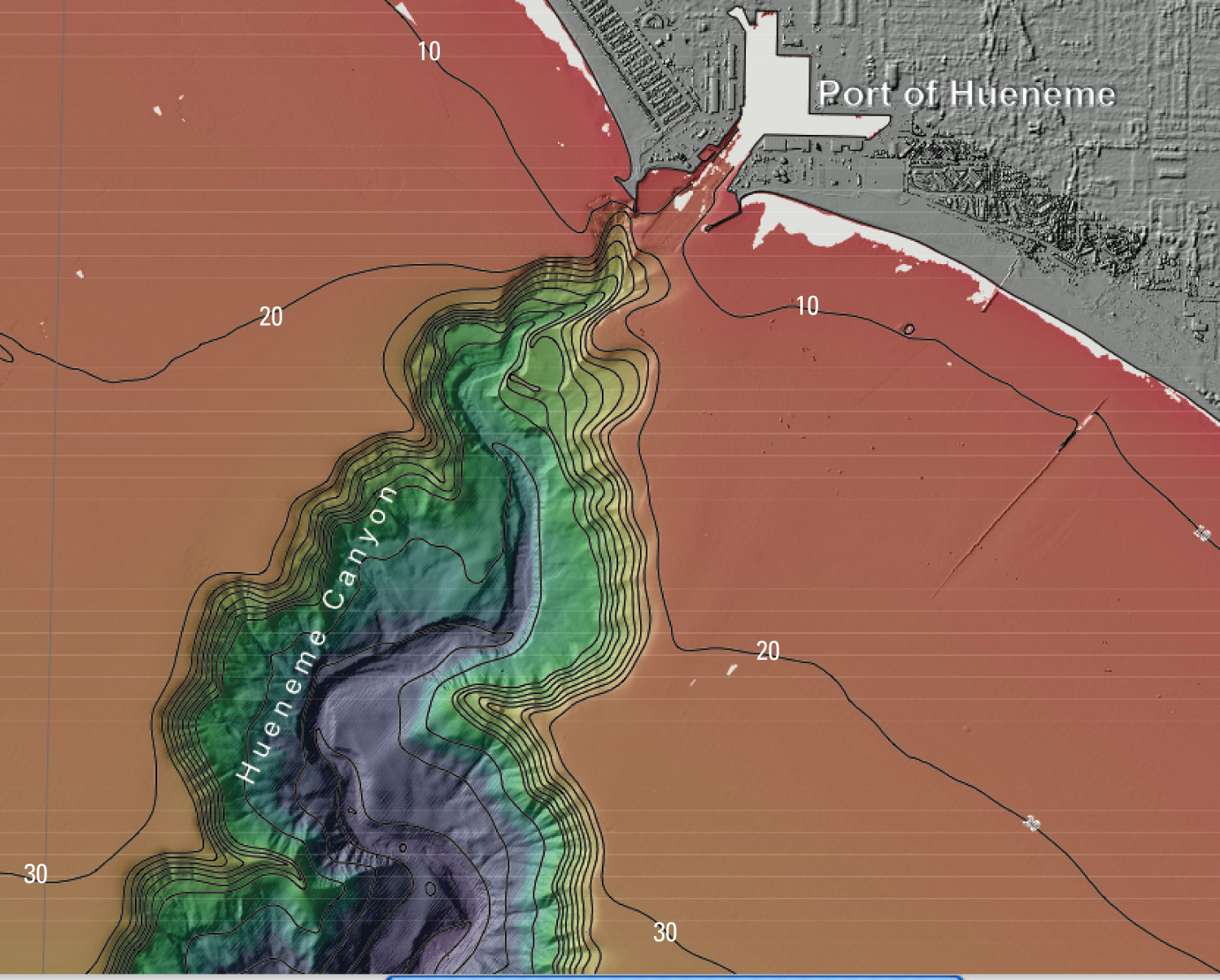
Above: Hueneme Canyon was named for the nearby Port Hueneme (the city’s harbor, Port of Hueneme, is labeled here), about 90 kilometers (55 miles) west-northwest of Los Angeles, California. Detected in 1855 during Coast Survey sounding operations, Hueneme Canyon is possibly the first seafloor canyon to be discovered. This view is an excerpt from sheet 1 of USGS Scientific Investigations Map 3225. Contours in meters. Image Courtesy: soundwaves.usgs.gov.
What Can Be Named?
The ACUF accepts names for both major and now minor features. The first choice of a specific term, where feasible, should be one associated with a geographic feature (previously approved examples include Aleutian Ridge, Aleutian Trench, Peru-Chile Trench, Barrow Canyon). The specific term should be combined with a generic term selected from ACUF’s list of 78 “feature designation names,” which ranges from “apron” to “valleys” and includes definitions to guide usage. You can submit a feature name with a generic term that is not on the list, but know that ACUF members will use resources such as the American Geosciences Institute’s (AGI) Glossary of Geology and Dictionary of Geologic Terms to verify that the proposed geographic feature name fits accepted definitions.
Specific names may be used to commemorate ships or other vehicles, expeditions, or scientific institutions involved in the discovery of the feature, or to honor the memory of famous people.
In cases where prior names were approved by the U.S Board on Geographic Names or appear in a body of scientific papers or charts, ACUF supports continued use of the major feature name.
Can You Name a Feature after a Living Person?
Yes, you can, but you need to document how the person fits the following criteria: “If names of living persons are used, surnames are preferable, and they should be limited to those who have made an outstanding or fundamental contribution to ocean sciences.”
Inappropriate names include those of individuals occupying high offices who have not contributed directly and significantly to the knowledge of the oceans or undersea topography.
How Do You Make a Formal Submission?
You need to fill out a form specific to proposing undersea features. The more detailed your description the better, including coordinates, description of the feature, any prior map or chart references, reason for choice of name, discovery facts, any other supporting materials, and information about the submitter.
This is where your background work really helps ACUF members. If you are proposing a number of names in an area that has been mapped with high-resolution methods for the first time, try to relate the names you select to nearby major features with previously approved names. This means that a new name might be East or West “X Ridge” (where “X Ridge” is the previously approved name of a major feature), or new proposals might form a cluster of related, historically meaningful names such as Crockett Valley, Bowie Knob, and Travis Fan, all associated with the previously named Alamo Plateau.
If your proposed name recognizes a formal entity, such as an organization or federally recognized tribe, be sure to use the official name.
Where Do You Find the Submission Forms?
The form, as well as the standardization policy document that provides principles for naming features and a list of feature designation names, can be found at http://earth-info.nga.mil/gns/html/underseafeatures.html.
Questions?
You can contact me at srussell@usgs.gov or the ACUF Secretary at underseafeatures@nga.mil.