
The sinking of the Deepwater Horizon in the Gulf of Mexico led to uncontrolled emission of oil to the ocean, with an official government estimate of 5.0 million barrels released. Among the pressing uncertainties surrounding this event is the fate of 2 million barrels of submerged oil thought to have been trapped in deep-ocean intrusion layers at depths of 1,000–1,300 m. Here we use chemical distributions of hydrocarbons in >3,000 sediment samples from 534 locations to describe a footprint of oil deposited on the deep-ocean floor. Using a recalcitrant biomarker of crude oil, 17(H),21(H)-hopane (hopane), we have identified a 3,200-km2region around the Macondo Well contaminated by 1.8 ± 1.0 × 10⁶ g of excess hopane. Based on spatial, chemical, oceanographic, and mass balance considerations, we calculate that this contamination represents 4–31% of the oil sequestered in the deep ocean. The pattern of contamination points to deep-ocean intrusion layers as the source and is most consistent with dual modes of deposition: a “bathtub ring” formed from an oil-rich layer of water impinging laterally upon the continental slope (at a depth of 900–1,300 m) and a higher-flux “fallout plume” where suspended oil particles sank to underlying sediment (at a depth of 1,300–1,700 m). We also suggest that a significant quantity of oil was deposited on the ocean floor outside this area but so far has evaded detection because of its heterogeneous spatial distribution.
Editor’s Note:
Dr. Roffer wanted this report to remind everyone that the British Petroleum’s (BP) Deepwater Horizon oil spill tragedy and environmental disaster is still with us. The U.S. National Academy of Sciences is considered the highest source of science in the country and well respected around the world. This science report was reviewed many times by respected scientists, and their results have been validated by other highly respected researchers from other institutions such as Univ. of South Florida, Univ. of Georgia, and Florida State Univ.
This is a snippet from a larger report – please click here for the FULL report.
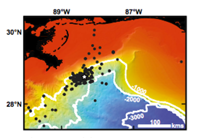
Above: Map of the northern Gulf of Mexico showing the sampling locations (black dots) and the Macondo Well (white star) overlaid on the National Geophysical Data Center Coastal Relief Model bathymetry.


