ROFFER’S OCEAN FISHING FORECASTING SERVICE, INC. TOLL FREE 800 677-7633 & (321) 723-5759 // WWW.ROFFS.COM
ROFFS™ FISHERIES OCEANOGRAPHIC ANALYSIS FOR THE VEATCH CANYON TO POWELL CANYON OFFSHORE (LAT./LONG.)
UPDATED ON WEDS. 23 APRIL 2014 FOR WEDS. P.M. & THURS. FISHING ONLY
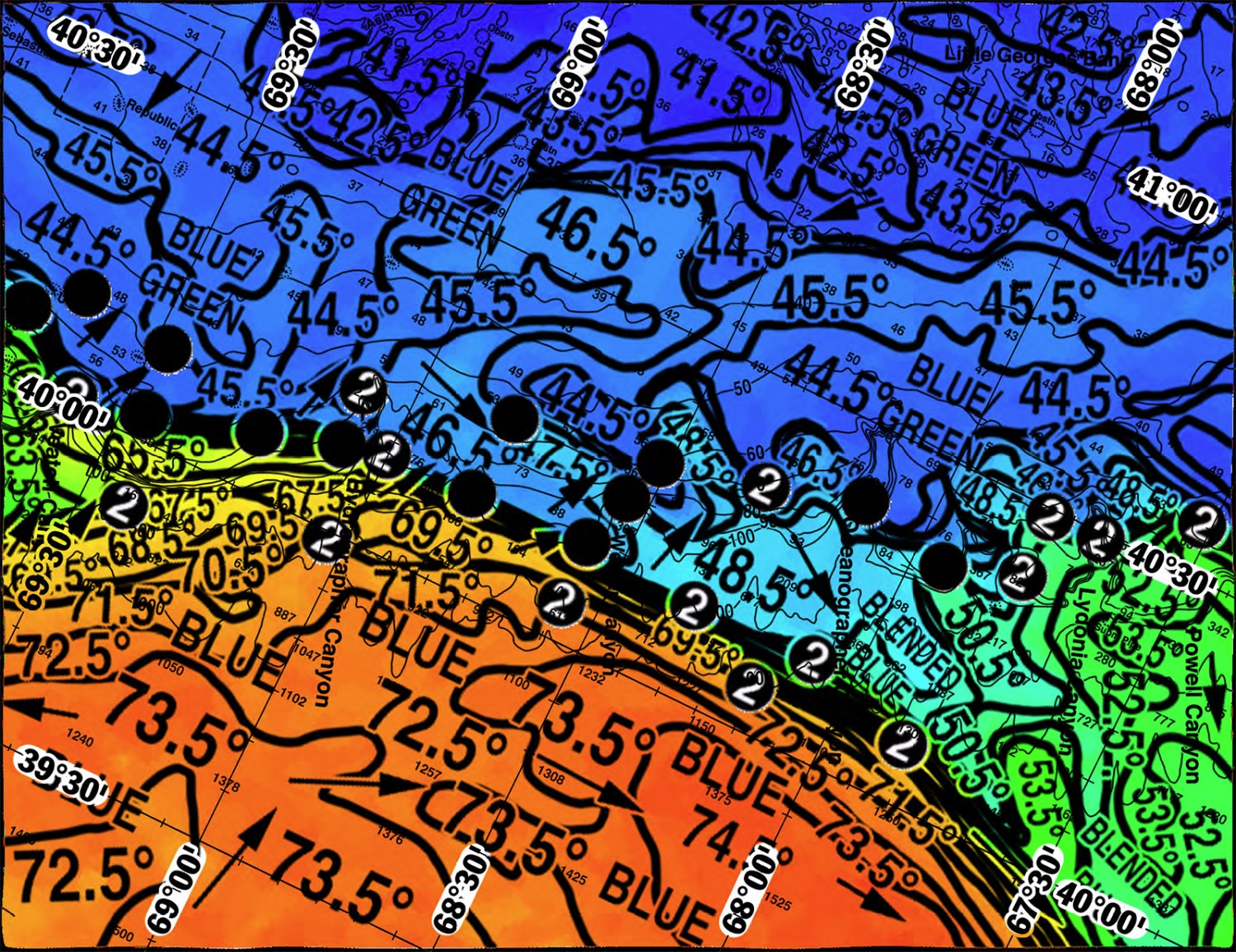
Based on a multiple factor analysis, the symbols (hot spot dots) mark the areas where bait concentrations are expected and where fishing action is expected to be better compared with other (non-marked) areas. These are not based on dock rumors or hearsay fishing reports. Fishing reports are stated as such. You should start fishing where you recognize other signs of good fishing conditions near these marked areas. It is very important to use your sea surface temperature (sst°) gauge to locate the boundaries of the water masses, which are outlined. Rather than trying to find water based on the absolute temperature values shown on the map, search for the relative change in sst° where the water mass boundaries occur. Arrows indicate the main current direction. Numbers inside of the dots indicate the number of consecutive days that we have seen favorable conditions in that location. Broken lines (small dotted lines) are water mass boundaries detected from the ocean color (chlorophyll + CDOM) satellite data. Afternoon sst° are likely to be 1°F-2°F warmer than what is estimated for the morning and shown here.
We are able to use yesterday and this morning’s infrared SST imagery data, and yesterday’s MODIS ocean color/chlorophyll imagery, to provide this analysis. Overall, a relatively large, counter-clockwise rotating eddy feature (centered south of Hydrographer Canyon near 69°00’W & 38°30’N) is pushing the 65.5°F-73.5°F Gulf Stream inshore over the 100 fathom curve from Veatch Canyon to Welker Canyon, suggesting favorable conditions for tuna (bluefin, yellowfin and perhaps bigeye), swordfish and mako sharks (it may still be too early for marlin action). Fishing conditions between Oceanographer Canyon and Powell Canyon are not as favorable as those in the west, as the Gulf Stream pulls offshore here. Areas marked with the hot spot dots and the numbers two inside suggest increased chances of fishing action as we have observed favorable ocean conditions here for two days now.
With this in mind, favorable conditions for fishing action occur over the 50-100 fathom tip of Hydrographer Canyon near 69°06’W & 40°13’N (favorable, yet different, for two days), where a relatively cooler blue green 1°F water mass boundary (45.5°F- 46.5°) is expected to be replaced by a series of blended blue to blue 20°F Gulf Stream water mass boundaries (47.5°F-67.5°F) over the next 12-24 hours. Follow the series of blended blue to blue 20°F Gulf Stream water mass boundaries (47.5°F-67.5°F) westwards to where they are expected to push inshore over the 50 fathom wreck near 69°29’W & 40°10’N, to over the 48 fathom wreck near 69°40’W & 40°11’N over the next 12-24 hours, suggesting favorable conditions for fishing action. Additional increased chances for fishing action occur from over the 70-100 fathom eastern wall of Hydrographer Canyon near 69°00’W & 40°14’N, to over the 70-100 fathom eastern wall of Veatch Canyon near 69°36’W & 40°02’N (both favorable, yet different, for two days), where the current series of blended blue to blue 20°F Gulf Stream water mass boundaries (45.5°F-65.5°F) are expected to be replaced by a series of relatively warmer, blue 3°F Gulf Stream water mass boundaries (67.5°F-70.5°F) over the next 12-24 hours. If these water mass boundaries are not producing as much fishing action as you would like, continue offshore to over 500 fathom depths over Hydrographer Canyon near 69°02’W & 40°00’N, as well as over 500 fathom depths to the east of Veatch Canyon near 69°25’W & 39°54’N (also both favorable, yet different, for two days), where a series of blue 2°F Gulf Stream water mass boundaries (67.5°F-69.5°F) are expected to be replaced by the relatively warmer 70.5°F-71.5°F Gulf Stream water mass boundaries over the next 12-24 hours, suggesting favorable fishing action.
Over Welker Canyon, favorable conditions for fishing action occur over the 60-100 fathom tip of Welker Canyon near 68°35’W & 40°10’N, where a series of blue green to blended blue 2°F water mass boundaries (45.5°F-47.5°F) are expected to be replaced by a series of 23°F Gulf Stream water mass boundaries (46.5°F-69.5°F) over the next 12-24 hours. Additional chances for increased fishing action occurs further south, over the 100 fathom western wall of Welker Canyon near 68°35’W & 40°10’N, eastwards to over 500 fathom depths near 68°20’W & 40°10’N, as well as over 1000 fathom depths over Oceanographer Canyon near 68°05’W & 40°10’N (both favorable, yet different, for two days), where the current series of 23°F Gulf Stream water mass boundaries (46.5°F- 69.5°F) are expected to be replaced by the relatively warmer 3°F water mass boundaries (69.5°F-72.5°F) over the next 12-24 hours.
Offshore, over 500 fathom depths south of Welker Canyon near 68°35’W & 40°05’N, to eastwards over 1000 fathom depths near 68°10’W & 40°05’N, additional increased chances of fishing action occur where a series of 3°F water mass boundaries (69.5°F- 72.5°F) are expected to be replaced by a 1°F water mass boundary (72.5°F-73.5°F). Between Oceanographer Canyon and Powell Canyon, the Gulf Stream water mass boundaries are pulling offshore, which
experience suggests is not favorable for forming new concentrations of fish, suggesting slow and scattered fishing action. Hence, better fishing action is likely to occur to the west of this area.
Verbal updates are free between 10:30 AM and 11:59 AM (eastern time) only, please call. Thank you for not sharing this analysis with non-paying fishermen. We survive on your honesty. ROFFS™ Hours: March 31 – May 02: Mon. – Fri. 9:00 AM – 6:00 PM. Saturday to be determined by demand by Wednesday 5:00 PM. Remember you can order and/or purchase your fishing analyses from our website (https://roffs.com/ and click on Order Analyses button) or by email.


